Route Editor

| Guide | ♦ | 8 Triplogs | 0 Topics |
details | drive | permit | forecast | route |
stats |
photos | triplogs | topics | location |
| 40 | 8 | 0 |
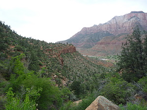
Hike from the Campgrounds by squatpuke  If driving, park your vehicle at the far end of the overflow parking lot directly north of Visitor Center. If camping from Watchman Campground, you can easily walk along side this parking lot and continue up the service road (that leads to employee dorms) until you see the signed trail head.
The trail's endpoint offers spectacular views of the entire south region of Zion NPS, Springdale and the Virgin River. Great seating is located everywhere at the Viewpoint; fantastic location to take a break. Return the way you came or complete the loop. Restrooms located at Visitor Center. The Watchman Trail is highly exposed - come prepared with sun protection and plenty of water.
Check out the Official Route and Triplogs. Leave No Trace and +Add a Triplog after your hike to support this local community. | ||||||||||||||||||||||||||||||||||||||||||||||||||||||||||||||||||||||||||||||