Route Editor

| Guide | ♦ | 22 Triplogs | 0 Topics |
details | drive | no permit | forecast | 🔥 route |
stats |
photos | triplogs | topics | location |
| 235 | 22 | 0 |
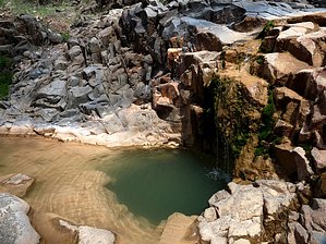
Bring some carrots for the horses by kingsnake  Overview OverviewThis is a popular trail -- I saw two other groups on a weekday -- but not crowded and appropriate for dogs & children. If it is dry season, it will be a bummer, as the falls will at best be a trickle. So, you will probably want to come in early spring, when there is mountain snow runoff, or monsoon season when there is rain runoff. Warning Of course, in monsoon season, beware flash floods: The canyon is narrow, with steep, but mostly climbable, sides. Also, watch for bees/yellowjackets, which tend to congregate near the pools.
The parking area is about 50 yards west of the trailhead, which is a gap in the barb wire fence. About 100 yards down the very benign jeep trail is the first gate. The trail itself would be drivable for the first mile, maybe a little more, if there was a way in. At 0.6 miles, on the west side of the trail are the remains of an old vehicle. Looks like maybe an early 50s light truck. As of June, 2013, all that's left is the cab; there was a lot more back in May, 2012. At 0.75 miles, there is an intersection. Stay left. At 1.1 miles, you will intersect Gordon Canyon Creek. If it is dry here, the falls are likely to either be dry or barely trickling. Somewhere in this area, there are likely to be several free-range domesticated horses. It seems like most people encounter two browns and two whites. They are friendly. Bring some carrots. At 1.4 miles, there will be another gate. At 1.7 miles, there will be a low wood structure that at first looks like a shelter but is actually a hunting blind, with a fire ring. After the blind, the jeep trail disappears, and you will begin either creek walking, or working your way along rock ledges, or across dead-fall strewn hillsides. Many of the rocks will be scattered with crawfish parts. Even in the dry season, there may be some stagnant pools in the creek. At 2.4 miles, you will reach the falls, which are maybe 20 feet high. Gate Policy: If a gate is closed upon arrival, leave it closed after you go through. If it is open, leave it open. Leaving a closed gate open may put cattle in danger. Closing an open gate may cut them off from water. Please be respectful, leave gates as found. The exception is signage on the gate directing you otherwise. Check out the Official Route and Triplogs. Leave No Trace and +Add a Triplog after your hike to support this local community. | |||||||||||||||||||||||||||||||||||||||||||||||||||||||||||||||||||||||||||||||||||||||||||||||||||||||||||||||||||||||||||||||||||||||||||||||||||||||||||||||||||||||||||||||||||