 Route Editor

| Guide | ♦ | 5 Triplogs | 0 Topics |
details | drive | permit | forecast | route |
stats |
photos | triplogs | topics | location |
| 5 | 5 | 0 |
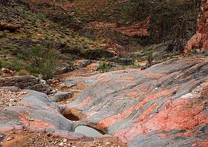
Connector Options by nonot   Overview OverviewTrinity Canyon Complex contains three known connector routes useful for off-trail travel in the Grand Canyon. Warning This area is neither maintained nor patrolled by the Park Service, and it can be scorching hot with minimal (and bad tasting) water in the area. Be comfortable with travel through remote places.
History Butchart and Steck have written enough on this area. As far as I know, it's only attraction is the ease with which one can connect to other more exciting areas of the canyon. Trinity Canyon is named because it has three distinct arms. Hike Trinity Canyon, in its lower parts, consists of what is called "basement rock." I am told this rock is over 4 billion years old and the oldest exposed rock on earth. Not being a geologist, I pass on these trivia bits at face-value. It is a rather attractive mix of what appears to be black/dark-gray granite with veins of pink. I can't quite compare it to anything else I've seen. Lower Trinity: It has been reported that lower Trinity beneath the confluence of the East Arm and Main (West) Arm is traveled only a short distance before reaching impassable dryfalls. There is no access to the Colorado River. I was unable to confirm these reports first-hand. I have seen photos of people stopped by a dryfall who traveled up the bottom of lower trinity from the river on raft trips. East Arm: The East Arm is the shortest of the three arms of Trinity, as it is destined to dead-end into Shiva. This arm of the canyon consists of fragmented rock jumbles. Travel is not particularly easy, but there are no technical scrambles. It has two good features: 1) The "Fault" access is into this canyon from the east side; this allows easy hiking access to the Isis-Cheops Saddle Route. (Generally, no scrambling needed). 2) Either directly across from the "Fault" access, or a short distance north, there are western leading exits onto the Tonto layer. This provides (reportedly) faster access to the North Arm than staying directly in the canyon. Main (West) Arm: The Main Arm is the longest of the three and travels in a generally northwesterly direction. A short distance from the confluence with the east arm is what is known as the Trinity Tanks, which is where a small seep can usually be found. Two potholes hold maybe 10 gallons each of water for quite some time after a rain, though I wouldn't want to filter out of them unless I had no other choice. Be warned, the water, though clear, tastes awful. I recommend something to mix in it, such as Gatorade. Travel up the main arm is easy, it is like walking along a gravel beach. The terrain is very flat. While I did not travel all the way to the head of the main arm, it appeared to be the same consistency for as far as I could see past where I turned around. No route has been reported near the head of the main arm, but two routes are reported that head south and west. One of them at the end of the posted GPS route that utilizes a small drainage. The other about halfway to this point that is more of a direct scramble. You can also access the north arm this way. North Arm: The North Arm takes one to the Shiva-Isis saddle. I believe there are two ways to use the North Arm, though I have only confirmed one route in-person. The first is direct travel up the main arm, turn right, and head up the north arm. The second is to use the East Arm exits to get onto the Tonto layer and shortcut to the North arm about halfway. I am told the latter is much faster. This is true because the North arm consists of jumbled rocks and is nearly a constant rock-scramble. Although not technical, it is slow going. Every two steps, you are generally going up 2-3 ft onto another rock. The upper part of North Arm is useful as a Redwall Route. Continuing up the north arm, staying in the main part of this drainage, you will climb until you get to a narrow slot that takes you through the Redwall. If descending from above, make sure you begin descent AT THE SADDLE and not the drainage that starts a bit southwest of the saddle. This slot is difficult for non-rock climbers as there is about an 8 ft stemming section that one must upclimb/downclimb. Other than this one (perhaps YDS class 3-) obstacle, the rest is not difficult to travel, though perhaps moderate scrambling. A partner assist may help those uncomfortable with doing this slot in groups, especially with packs on... since it is narrow, packs are problematic without an extra person around. Once up onto the saddle, travel west is possible on this layer, leading to the Shiva Entrance/Exit Route from Upper Phantom, or to the Shiva Saddle, north of Shiva that divides Outlet from the East fork of Dragon. Water Sources Trinity Seeps, though not reliable, will likely have water in spring or after rain. Be warned, it tastes foul, though the seeps are clear. The pothole tanks in this area will hold water but are gross. Camping Camping is difficult when you want to get out of the drainage to camp in a safe spot. Do not camp in the bed of the canyon, as any night rains will wash you away in a flash flood. I have no good suggestions, be on the lookout for a spot. Utilize the exit routes to access the Tonto (or above the Redwall) layer where the ground is flatter and maybe clear enough in areas for a tent or two. Check out the Official Route and Triplogs. Leave No Trace and +Add a Triplog after your hike to support this local community. One-Way Notice This hike is listed as One-Way. When hiking several trails on a single "hike", log it with a generic name that describes the hike. Then link the trails traveled, check out the example. | |||||||||||||||||||||||||||||||||||||||||||||||||||||||||||||||||||||||||||||||||||||||||||||


