Route Editor

| Guide | ♦ | 20 Triplogs | 0 Topics |
details | drive | permit | forecast | route |
stats |
photos | triplogs | topics | location |
| 219 | 20 | 0 |
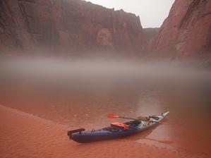
Floating on down the Colorado by PaleoRob   Overview OverviewGlen Canyon is a touchstone for western river runners. It evokes redrock canyons buried beneath the still blue waters of Lake Powell. Not all of Glen Canyon is submerged, however. Fifteen miles of the Colorado River runs through lower Glen Canyon between Glen Canyon Dam and Lee's Ferry. With a kayak, you can explore this remnant! Warning The canyon can be blazingly hot in the summer, and the water is hypothermia-inducing year-round. There is very little shade anywhere along the river banks and no place to easily get out of the canyon. Fishing boats and float trip tours can roar up and down the river creating wakes with little regard to a small kayak.
In 1963 the diversion tunnel gates at Glen Canyon Dam were closed, forever sealing the fate of Glen Canyon upstream of the new dam. Most river runners wrote all of Glen Canyon off as a loss and moved on to the Grand Canyon, the Green, or other rivers here in the West. Though, not all of Glen Canyon was submerged. Until 1980, when Lake Powell filled for the first time, much of the extreme upper reservoir was riverine. And, sitting just below the dam, stretched 15 miles of un-dammed Glen Canyon. This area can still be explored by those willing to get their kayak hauled up the river near Glen Canyon Dam. Hike To kayak this stretch of river, you need to have your kayak "backhauled" up towards the dam by the float trip concessionaire - Colorado River Discovery. They have information at their website https://www.raftthecanyon.com, or they can be reached at 887-522-6644. Prices depend on the number of people and the number of boats. Once you have been backhauled to the furthest upstream gravel bar, you will need to rig your kayak and shove off into the current. This is generally a one day trip with good flows, but it can be stretched out if you want to hike or fish. Water Sources You are on an unsilty river, but it is recommended that you bring all you need. Camping Several developed campsites can be found along the river banks. These are the only legal campsites in Glen Canyon. Gate Policy: If a gate is closed upon arrival, leave it closed after you go through. If it is open, leave it open. Leaving a closed gate open may put cattle in danger. Closing an open gate may cut them off from water. Please be respectful, leave gates as found. The exception is signage on the gate directing you otherwise. Check out the Official Route and Triplogs. Leave No Trace and +Add a Triplog after your kayak trip to support this local community. | |||||||||||||||||||||||||||||||||||||||||||||||||||||||||||||||||||||||||||||||||||||||||||||||||||||||||||||||||||||||||||||||||||||||||||||||||||||||||||||||||||||||||||