WOW! Spectacular Yosemite scenery & one challenging hike! 8+ miles through some amazing Yosemite highlights - amazing views of Glacier Point, Illilouette area & the spectatcular falls, Panoramam Cliffs, thundering waters of Nevada & Vernal Falls, trailside rainbows, Bird's eye view of Yosemite Valley, Liberty Cap, Half Dome and many more...
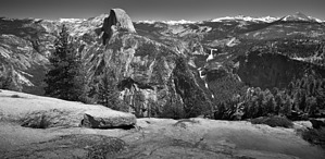
Glacier Point is 3200ft directly above the Yosemite Valley floor. Take the short paved trail to the view point & enjoy the spectacular panoramic - Half Dome dominates with Nevada & Vernal Waterfalls as well as the Yosemite Falls against a backdrop of the majestic peaks of the High Sierras.
The Panorama TH is clearly signed. The trail starts down immediately through a recovering open forest (old burn) with buckbrush, manzanita, oaks and other conifers. Views of Half Dome & the falls are framed by some older pines. Enjoy the views and head down on some long switchbacks towards Illilouette Creek. The initial 1/2 mile of the trail is somewhat crowded but it eventually thins outs. At mile 1.75 you will head left towards Illiloutte Falls (2.2 miles). Illilouette Falls tumbles down 370ft down. Stay safe as you look for the viewpoints to allow you to see the whole falls . Enjoy views of this hidden falls ( you cannot see this from the valley floor) . You will continue on the trail - cross Illilouette Creek and begin to climb up in earnest -~ 700+ft in 1.5 miles as you climb out of Illiloutte Creek and the top of Panorama Wall ( a huge cliff above the Merced River Canyon as it leads from Yosemite Valley to Little Yosemite Valley). This is the only real uphill for this trail. You reach Panorama Point for some stunning views of Yosemite Valley, Upper & Lower Yosemite Falls and the Royal Arches. You climb a bit more, traverse around & are at a 3 way junction. Head left again and switchback down (~10) to the junction with the John Muir Trail. Keep right (heading northeast) here to head to Nevada Falls. The trail is wet and you will cross numerous streams (Spring/early summer) as you reach the top of the falls. Enjoy the granite slabs and the thunderous sound & spray from the Merced river falling ~ 600ft and crashing onto the rocks below. This is very mesmerizing to watch. Cross the river and head to the dizzying view points by the guard rails. Stay safe in this area. Look for rock climbers on Liberty cap. Head on further along the trail ( over rocks here) and you will reach the junction with the Mist Trail. (Turn Right here to head down Mist-- This is not well marked) . Head on down the steep steps with the thundering Nevada Falls on your left and the 700ft Liberty Cap to you right. There is a short section where the mist from the falls will drench you. We saw an amazing rainbow at the base of Nevada Falls in this area. The # of people on the trail will grow - Both Nevada & Vernal falls are popular destinations hiking up from the valley floor. You will cross the Merced at the footbridge at Emerald Pools and & continue to the top of Vernal Falls (6.5 miles). Look down on the Mist Trail from this vantage point & look for rainbows! Head down on the left of the falls. After a short wet stairstep downhill you stop & don your rain gear ( if you have not already got it on) and step out into the icy cold mist coming from Vernal as you head down the wet "Mist Trail"! At base of falls continue west, mist trail levels out , keep right at 3 way intersection with JMT & follow the south bank. Cross the foot bridge & you will find a water fountain & bathrooms. The path from here to Happy Isles is paved. You round Grizzly peak & are treated to a view of Illilouette falls across Illilouette Gorge that you crossed a few hours ago on the Panorama Trail. The trail crosses Happy Isles Bridge & arrives at the shuttle bus center. Now you have seen & experienced a special slice of Yosemite!
Notes:
1. Stay safe - This hike has exposure at the lip of each of the waterfalls you cross. The granite can be slick and respect the safety railings.
2. Streams can be swift and have boulders in them. Don't try to cross or swim. Use the foot bridges.
3. Filter the water you drink.
4. Make sure you have your sun protection on. Much of the Panorama Trail does not have shade.
5. If you plan on hiking up from Happy Isles or other TH - make sure you have transportation arranged for your return from Glacier Point.
6. You have other descent options - 4 mile trail, John Muir Trail, Clark Point cut across.
 Route Editor