Route Editor

| Guide | ♦ | 10 Triplogs | 0 Topics |
details | drive | no permit | forecast | route |
stats |
photos | triplogs | topics | location |
| 35 | 10 | 0 |
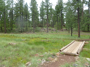
A Walk with the Skeeters by kingsnake   2020 Note 2020 NoteThe forest was heavily harvested, expect less shade and wildlife for a decade or two. This hike is a small town with trees and water, the equivalent of hiking the Phoenix Mountain Preserve. Located north of, and immediately adjacent to, the faux log "cabins" of the Pinetop Lakes Country Club, it is a locals' trail rather than a destination hike. If you combine it with the extensively interconnected White Mountain Trail system, you can get more distance and AEG, but at least in this segment, it is still urban -- or at least as urban as Pinetop gets.
The trail widens out along Billy Creek. Fletcher Tank is the highlight of the hike, with lots of yellow flowers. As far as the "witty" description: Because the hike is almost entirely near water, of some sort, there are mosquitoes everywhere, but especially here. You might want to spray some Off! before you start, but the skeeters are not as numerous, large, or aggressive as in the upper Midwest, so maybe not. After Fletcher Tank and about 1.5 miles, the trail turns north, recrossing Billy Creek, for your second "climb" of the day. (Another 40 feet or so.) As you descend to Thompson Creek, the traffic noise will begin to lessen, predominantly covered by the water's burbling. Just after the pond, you will cross north across the water. The trail splits here: Stay right, or you will find yourself on the connector to the Blue Ridge Loop. After the connector, you will cross back to the south bank of Thompson Creek for your penultimate 40-foot "climb" at the 3-mile mark. Cross Thompson Creek one final time, perform your final ascent, avoid the booby trap, and you will be back at the trailhead in under 90 minutes. This probably took me longer to write than it will take you to hike it. If you are from out of town, use it for the same reason I did: As a way to get in a few quick miles, to warm you up for bigger things, and to acclimate to the elevation. Check out the Official Route and Triplogs. Leave No Trace and +Add a Triplog after your hike to support this local community. | |||||||||||||||||||||||||||||||||||||||||||||||||||||||||||||||||||||||||||||||||||||