Route Editor

| Guide | ♦ | 20 Triplogs | 0 Topics |
details | drive | no permit | forecast | map |
stats |
photos | triplogs | topics | location |
| 10 | 20 | 0 |
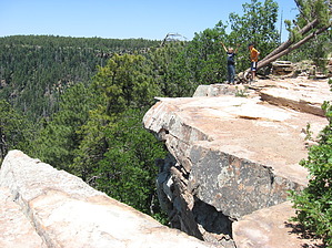
A sampling of Rim trails by Woodsnative  This route follows sections of four different trails through the beautiful forests along the Mogollon Rim. The trails include a single track, old road, and even paved sections to add to the variety. Except for the viewpoint areas on the Rim, the majority of this hike will find no other hikers on the trail. This route follows sections of four different trails through the beautiful forests along the Mogollon Rim. The trails include a single track, old road, and even paved sections to add to the variety. Except for the viewpoint areas on the Rim, the majority of this hike will find no other hikers on the trail.Our original plan was to camp near the trailhead for Drew Trail #291. Then follow gpsjoe's Mogollon Rim Vista Loop route, but the forest was closed below the rim due to fire danger. We achieved nearly the same result by creating a loop above the rim, but without the hill climbing.
The next day we headed to the Carr Lake Trailhead, which sits at the beginning of FR 9350 about a mile away from the Drew Trailhead. It has a restroom facility but no water. The Aspen Trail #40 begins here and heads northwest, toward a series of loop trails popular with mountain bikers. To get to the General Crook Trail, we crossed FR 300 to the north side. Here the trail is a single footpath but well-worn and marked with trail chevrons and an occasional cairn. Eventually, it follows an old roadbed, which may have been the military road. It looked like it had been changed by modern equipment. The map we had on hand showed the trail crossing over FR 300 twice, but the trail markers we followed kept us north of the road until we reached the north-south road into Woods Canyon Lake. The Meadow Trail #505 runs parallel to that road, and we followed this paved section south for half a mile, only having to dodge one family of bikers along the way. Soon we reached the Rim Lakes Vista Trail and headed east. This trail has excellent views, and many people park to have a look. There are a good number of wildflowers along this section. Eventually, the paved trail becomes dirt, somewhere west of the Military Sinkhole Trail. To begin our return route, we crossed to the north side of FR 300 and entered the actual sinkhole. The forest floor here was full of ferns amidst the trees, though we didn't see any water. At the back of the sinkhole, we found a bed of springy pine needles, which was a great place to put up our feet and have lunch. Just to the north, we re-encountered the Crook Trail and headed west. This section of the trail was not in good shape. Only the tree chevrons showed the way since there was no path and many fallen trees. This section paralleled a power line road, and we were glad to return to the much better trail on the west side of the Meadow Trail. Side note We refilled our water reservoirs at the Crook Campground at the intersection of the Crook Trail and the Meadow Trail. Check out the Triplogs. Leave No Trace and +Add a Triplog after your hike to support this local community. | ||||||||||||||||||||||||||||||||||||||||||||||||||||||||||||||||||||||||||||||||||||||||||||||||||||||||||||||||||||||||||||||||||||||||||||||||||||||||||||||||||||||||||||||||||||