 Route Editor

| Guide | ♦ | 51 Triplogs | 1 Topic |
details | drive | permit | forecast | route |
stats |
photos | triplogs | topic | location |
| 49 | 51 | 1 |
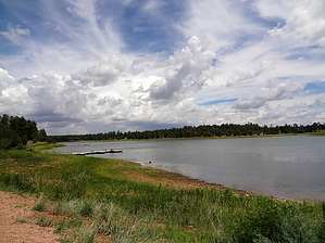
shallow lake over Adair by black_toes  Overview OverviewThis trail is located in the 800-acre Fool Hollow Recreation Area, about three miles northwest of downtown Show Low. It arcs in a sloppy "U" around the southern end of the shallow 150-acre lake, which has an average depth of 23 feet. Located in Apache-Sitgreaves National Forest, the park was opened in 1994 and is managed by Arizona State Parks. A picnic area with five ramadas, a boat ramp, and three fishing docks dominates the western shore with a campground, boat ramp, two fishing docks, and a store on the remote east side. The store sells snacks, drinks, bait, fishing equipment and rents canoes and kayaks. Trail Fool Hollow Lake Trail is a pleasant and almost effortless walk. This flat path runs at the lake's edge from the boat ramp on the western shore to the boat ramp on the eastern side. The western trailhead begins without signage just below the Bluebird picnic area on a cement walkway that leads down to a fishing dock from the parking lot. From there, the trail turns south for a half mile before coming to Wildlife Island, an excellent spot for bird watching and photography. In October of 2013, with the lake level down 5-10 feet, it was an island in name only. I counted 67 ducks in one small area, most of them mallards but a few redheads too. The southeast corner of the lake opens up into a meadow, painted in color, I suspect, during wildflower season. The trail swings back north and up a small incline into a forested area before coming to the boat dock and the end of the trail.
Submerged beneath the lake is the town of Adair. It is named for a farmer, Thomas Jefferson Adair, an Indian who settled in the area in 1885. Locals said only a fool would try to farm there. Thus the name "Fool Hollow," so the story goes. Uses Hiking, biking, jogging, fishing, motor boating, kayaking and canoeing, bird watching, stargazing, and I suppose SCUBA if you have a hankering to find old Adair. Check out the Official Route and Triplogs. Leave No Trace and +Add a Triplog after your hike to support this local community. One-Way Notice This hike is listed as One-Way. When hiking several trails on a single "hike", log it with a generic name that describes the hike. Then link the trails traveled, check out the example. | ||||||||||||||||||||||||||||||||||||||||||||||||||||||||||||||||||||||||||||||||||


