Route Editor

| Guide | ♦ | 2 Triplogs | 0 Topics |
details | drive | no permit | forecast | 🔥 route |
stats |
photos | triplogs | topics | location |
| 11 | 2 | 0 |
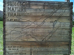
A Trail Just for Vacationers by azdesertfather   If you are looking for a great little vacation with some hiking, mountain biking, and birdwatching to boot, then Sunglow is the place to go. (Please note that this trail is on Sunglow Ranch property, so I assume it is accessible only to patrons.) If you are looking for a great little vacation with some hiking, mountain biking, and birdwatching to boot, then Sunglow is the place to go. (Please note that this trail is on Sunglow Ranch property, so I assume it is accessible only to patrons.)Sunglow Ranch is a beautiful 475-acre resort in southeastern Arizona, nestled right against the base of the Chiricahua Mountains. It is a traditional western guest ranch with many amenities, including a 45-foot solar heated pool, hot tub, fitness room, bocce and horseshoe courts, a lake for canoeing, and more. Horseback riding is also available on site for a charge, but they provide mountain bikes and helmets, fishing equipment, a canoe, binoculars for birdwatching, and more at no charge. A stay at the resort comes with your choice of breakfast and dinner items off their menu. These meals are included and prepared by a chef that will make you keep coming back for more; everything is made from scratch (mostly from their garden) and is so good! The owner is a great, laid-back guy who manages the property and helps serve and carry on a conversation with diners at mealtime.
There are a couple of spur-to-lookout points on the trail, and there is an added loop in if you want a great view of the valley below. A great little trail to go on with the family, with access to several other trails into the Chiricahuas from the ranch. To find out more about Sunglow Ranch, you can visit them at www.sunglowranch.com Check out the Official Route and Triplogs. Leave No Trace and +Add a Triplog after your hike to support this local community. | ||||||||||||||||||||||||||||||||||||||||||||||||||||||||||||||||||||||||||||||||||||