Route Editor

| Guide | ♦ | 11 Triplogs | 0 Topics |
details | drive | no permit | forecast | route |
stats |
photos | triplogs | topics | location |
| 63 | 11 | 0 |
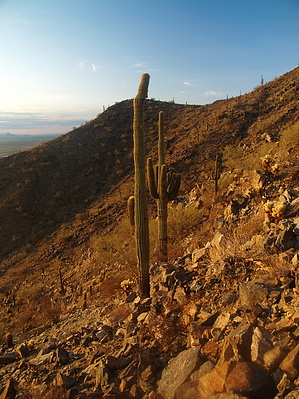
On top of the Casa Grande Mountains (almost). by PaleoRob  Overview OverviewThe Radio Tower / Bolt Trail loop combines the popular Radio Tower trail with the much less used (and more hiking-esque) Bolt Trail to take you to the second-highest point in the Casa Grande Mountains. Warning The trail is shadeless for most of its two miles. In addition, there is no water along the route. Please bring all you need and a little more. The usual Sonoran Desert hazards apply here - sharp rocks and plants, rattlesnakes, etc.
The Radio Tower trail is a road that was actually built to install and then maintain the radio towers near the summit of Casa Grande 2 (that is the real name on the map). The Bolt Trail is named after Casa Grande hiker and outdoor enthusiast Joel Bolt. There is a memorial to Joel at the base of the Bolt Trail. Hike While I first did this trail from top to bottom, I recommend doing it in the opposite direction. I will describe it in the preferred direction. The trail takes off originally down Hanna Road from the Hanna Road parking area. The scenery is the typical Sonoran Desert, with saguaros, ocotillos, and cholla. The trail dips down through two washes. As you are coming out of the second wash, on the right, you will see a cross labeled "Bolt Trail". Turn at the cross. The Bolt Trail takes off up the hillside. It is very lightly used, so it can be easy to lose. Trail maintenance crews have painted gray chevrons to point you in the right direction towards the top (though not to help out from above). Once you achieve the ridgeline that is just south of Hanna Road, the trail basically sticks to it. If you lose it, look for the chevrons. If there are none, simply follow the ridgeline. Eventually, the Bolt Trail intersects the Casa Grande Mountain Ridgeline Trail (described elsewhere). Simply turn right and follow this up to Casa Grande 2 (at 2332 feet above sea level, it is the second-highest point in the Casa Grande Mountains). Alternatively, you can continue south on the Ridgeline Trail to Peak 2350. Otherwise (or afterward), turn left on the Ridgeline Trail. This will take you past the radio towers and then onto Hanna Road. Follow the Hanna Road/Radio Tower Trail back down the flank of Casa Grande Mountain and back to your vehicle. Water Sources None. Bring your own. Camping Not allowed. Check out the Official Route and Triplogs. Leave No Trace and +Add a Triplog after your hike to support this local community. | |||||||||||||||||||||||||||||||||||||||||||||||||||||||||||||||||||||||||||||||||||||