This is likely a great time to hike this trail!  Check out "Preferred" months below, keep in mind this is an estimate.
  🔥

Victorine Crossing #101, AZ

Guide 6 Triplogs Mine 0 0 Topics
 
4 of 5 
Fav
Wish
0
details
drive
no permit
forecast
🔥
route  
stats
photos
triplogs
topics
location
65 6 0
Statistics
tap icons for details
Difficulty 2 of 5
Route Finding 3 of 5
Distance Round Trip 1.6 miles
Trailhead Elevation 7,088 feet
Elevation Gain -492 feet
Accumulated Gain 560 feet
Avg Time Round Trip 2 hours
Kokopelli Seeds 4.4
 Interest Seasonal Creek
 Backpack Yes
feature photo
Photos Viewed All MineFollowing
10  2019-08-09 MountainMatt
11  2016-06-21
Leonard Canyon & East Clear Creek
The_N
16  2015-09-13 ALMAL
14  2015-07-23 The_N
14  2015-05-27 The_N
Author
author avatar Guides 104
Routes 249
Photos 2,067
Trips 512 map ( 4,963 miles )
Age Male Gender
Location Phoenix, AZ
Associated Areas
list map done
Payson Region
Historical Weather
Trailhead Forecast
Radar Map
Expand Map
Preferred May, Oct, Sep, Apr → 9 AM
Seasons   Late Spring to Early Autumn
Sun  6:01am - 6:44pm
Official Route
 
0 Alternative
 
 Water
Historic Fire Perimetersacres
🔥 2018 Tinder Fire15.7k
🔥 2007 Wilkins Fire21.3 mi*
🔥 View (All) - over Official Route 🔥
*perimeter length in miles
Nearby Area Water
[ View More! ]
Fauna  Nearby
no photo labels yet
+Add > Photos to this Guide
then label as applicable
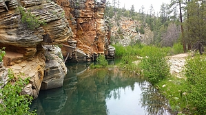
Likely the only good part of Leonard Canyon
by nonot

   Likely In-Season!
Overview
A hike down to a grotto of Leonard Canyon, hikers may continue up the other side into the Apache-Sitgreaves forest.

Warning
The trail is faint, be prepared to do a little wandering.

Note: Distance and elevation statistics are from the west side, down to the creek, and back up.

Hike
From FR137H, begin hiking the road; I believe it is FR 9712O. There will be a carsonite "trail" marker on the road directing you to the point where the trail leaves the road. The trail traverses a little north and then heads down a brush-free but relatively obscure route. It appears that elk have been using this trail much more than humans. Some downed trees and general steepness seem to cause the trail to braid a few times, but it is not difficult to find where it continues each time. Cairns were located along much of the trail, though towards the very bottom, the trail disperses as you near the creek.

At the bottom, you will emerge into what is likely the best part of Leonard canyon. When I visited, the creek was lightly flowing through this section. It is an Eden of green plants, elk, deer, and water birds such as mallards and great blue herons. Around the corner is a spot with possible swimming/wading, where a deep pool has formed.

You can hike upstream or downstream a bit, but there is no observable trail. Crossing to the other side and heading a bit north, you will find a flat area suitable for camping. The trail apparently heads up the rim here on the other side, though I didn't look for it.

Water Sources
Creek/pools - bring a filter.

Camping
Near the trail at the bottom of Leonard canyon are some camping options.

Check out the Official Route and Triplogs.

Leave No Trace and +Add a Triplog after your hike to support this local community.

2011-08-14 nonot
    WARNING! Hiking and outdoor related sports can be dangerous. Be responsible and prepare for the trip. Study the area you are entering and plan accordingly. Dress for the current and unexpected weather changes. Take plenty of water. Never go alone. Make an itinerary with your plan(s), route(s), destination(s) and expected return time. Give your itinerary to trusted family and/or friends.

     Permit $$
    None


     Directions
    or
    or
     Road
    High Clearance possible when dry

    To hike
    From Payson, head north on 87, past Strawberry, Clints Well, and the Blue Ridge Reservoir Campground. Just past the Blue Ridge Ranger Station, turn south on FR95, and take it until you cross East Clear Creek. Turn left immediately after the crossing onto FR96. FR96 will take the bridge over Barbershop Canyon and keep climbing. In a few miles, stay left on FR96, where it forks with FR321. T into FR137 and turn left. In a few miles, FR137 goes left, and FR137B goes right. Go right onto FR137B. In about 1.3 ish miles, FR137H will split off to the right. Drive not quite 2 miles to where FR9172O comes in on the right. You may want to park here.
    page created by nonot on Aug 14 2011 11:01 pm
    helpcorrectionissue

    end of page marker