 Route Editor

| Guide | ♦ | 5 Triplogs | 0 Topics |
details | drive | no permit | forecast | route |
stats |
photos | triplogs | topics | location |
| 20 | 5 | 0 |
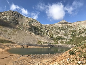
.. Two destinations = Twice the fun .. by Grasshopper High elevation TH Start at 10,740 feet; Three manageable creek crossings; Dense forest canopy part-of the way to Hope Lake at 11,867 feet; Spectacular wildflower displays during prime summer months with additional hiking on a defined use trail past Hope Lake and up the east slope for an additional .6 mile (+574 ft elevation) to gain the High Saddle Viewpoint/National Forest Boundary lines at 12,445ft elevation; Hike This Uncompahgre National Forest Trail is quite gradual starting off, winding up through the heavy forest canopy for the first ~1.5 miles with manageable creek crossings to negotiate. The trail then breaks away from within the denser forest areas to open up with nice views of the surrounding area including an interesting rust colored scree field that resembles mine tailings. The last 1.1 mile of trail section to reach Hope Lake is a fairly steep and rocky segment aided by switch-backs. In this climb segment, nice views to the northwest of "Trout Lake" (the large lake passed on the drive in) and to the northeast- "Vermilion Peak" (at 13,894ft) come into view.
Your second destination - "High Saddle Viewpoint/Forest Service Park Boundary" - is accessable via a defined use trail that heads up a slope from the east side of Hope Lake. This trail section is ~.6ml one way and +574ft elevation but worth the time and energy. This high saddle viewpoint is the forest boundary between Uncompahgre National Forest and San Juan National Forest (over the saddle and to the east). This high saddle at 12,445 feet elevation offers some excellent near and distant surrounding views down to Hope Lake and west to San Miguel Peak at 13,752ft (towering above Hope Lake). Expansive views and highlights NE/east/SE into the awesome San Juan National Forest are too many to detail here.. It should also be noted that at this high saddle a trail continues down to the south Mineral Creek Drainage in the San Juan National Forest possibly providing a backpack connection (at this writing it is not known if this SJNF trail has an official name and/or number). Check out the Official Route and Triplogs. Leave No Trace and +Add a Triplog after your hike to support this local community. One-Way Notice This hike is listed as One-Way. When hiking several trails on a single "hike", log it with a generic name that describes the hike. Then link the trails traveled, check out the example. | ||||||||||||||||||||||||||||||||||||||||||||||||||||||||||||||||||||||||||||||||||||||||||||


