This peak is named for George Scott, one of the early mining entrepreneurs in the Glob-Miami district. It seems fitting since the summit overlooks the enormous Ray mine open pit, and the mining activity looks like Tonka toys gone wild. This is a straightforward hike almost straight up the side of the mountain and combines solitude with a decent workout. Of course, hiking a mountain peak with your name is also an attraction if you happen to be a Scott.
The trailhead is just south of the Slash S ranch, which is an active cattle ranch. You will meet many of the inhabitants and a lot of their leavings. They seem to be reasonably calm, but one bull I encountered caused me to bypass his and his ladies' portion of the trail.
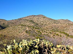
The hike follows a jeep trail along the top of a ridge, climbing towards the peak's south side. Along the way is a variety of mixed vegetation and cactus, including Yucca and Century plants in full bloom. There are a couple of prospects and what appear to be some springs though I did not climb down to verify. At a saddle near the top, the jeep trail splits into a southern and northern segment, and you follow the northern branch along the west side of the mountain for about a quarter-mile. At that point, it is easy to go straight up the mountain to the shade of some trees along the top ridge. There is no obvious trail, but there is also minimal brush or rocks. At the summit, the 360-degree views are interesting with Picketpost and various Superstition landmarks visible. Then there is the fun of watching the miners work. A small summit log is in a can and glass jar and does not show too many people stopping by.
WARNING! Hiking and outdoor related sports can be dangerous. Be responsible and prepare for the trip. Study the area you are entering and plan accordingly. Dress for the current and unexpected weather changes. Take plenty of water. Never go alone. Make an itinerary with your plan(s), route(s), destination(s) and expected return time. Give your itinerary to trusted family and/or friends.
Permit $$
None
Directions
Road
FR / Dirt Road / Gravel - Car Okay
To hike From Phoenix, east on 60 to Superior, then south on SR177 about 30 miles To Winkelman. North on SR77 15.9 miles to MP 153.6 where you turn left (west) onto Dripping Springs road. Follow the well-maintained dirt road 9.4 miles to the trailhead on the left. There is a nice spot to park off the road on the west. Cross the wash to the obvious trail/jeep track up the ridge. From Tucson, take SR79 north to SR77 and then on North through Winkelman to MP 153.6
 Route Editor


 This peak is named for George Scott, one of the early mining entrepreneurs in the Glob-Miami district. It seems fitting since the summit overlooks the enormous Ray mine open pit, and the mining activity looks like Tonka toys gone wild. This is a straightforward hike almost straight up the side of the mountain and combines solitude with a decent workout. Of course, hiking a mountain peak with your name is also an attraction if you happen to be a Scott.