Route Editor

| Guide | ♦ | 1 Triplog | 0 Topics |
details | drive | no permit | forecast | route |
stats |
photos | triplog | topics | location |
| 25 | 1 | 0 |
Canyons are inherently risky. Flash floods occur without notice on sunny days. Technical skills & surrounding topography knowledge required yet does not eliminate risk.
Small fry by nonot Warning: There is one rappel along this route, for this you will need: helmet, harness, locking biner, and rappelling device. You will need about 160ft of rope or perhaps a bit less. In most times of year you will want a wetsuit for the short swimming sections in this canyon. Do not enter this canyon if it has rained within the last 24 hours within 30 miles, for White canyon may be raging making exit impossible. Do not enter Fry Canyon if rain is predicted anywhere in the area!
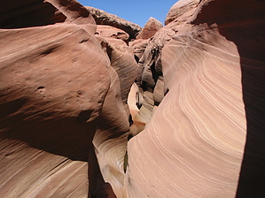
History: Along the way you will see a small Anasazi Ruins site, which is inaccessible from the bottom of the canyon. This canyon is sometimes hiked (exiting before the rappel) by guests of the nearby Fry Canyon Lodge. Hike: From the east side of the bridge there is a small parking area off the highway. Head upcanyon on either side and drop into the bottom of the drainage. Heading downcanyon before the bridge you will encounter some wading and swimming, put your wetsuit on here if you don't want to get your clothes wet. After getting through these briskly cold pools, hike down Fry for at least another mile or so, which is dry and perhaps a bit muddy. There are several exit routes on the left that can be used to leave the canyon before reaching the rappel. As you near White Canyon, Fry slots up and drops into a deep dark defile in the ground. Rap 50 ft from a bolted anchor on the right to a shallow pot with a continuance of the rappel of another 20 ft or so. (Alternative, rap 40 ft, downclimb/rap 10, and rap down the continuance, which may be more brutal on the rope.) A little swimming at the bottom will get you past the pools. As you continue towards White Canyon, look up and right for the Anasazi Ruins. When you hit White Canyon, head upstream (right) in White Canyon and go about 200 yards until you reach a section of the canyon wall on your right that looks like you can climb out. I found no cairns here but there is a faint trail that weaves up the wall of the canyon, it is about high YDS class 2. When you reach the top, follow the trails back to your vehicle, do NOT leave the trails and damage the cryptobiotic soil. Note: You can explore up or down White Canyon quite a ways from the junction of Fry/White if you have time, the canyon is quite nice in this area and seems seldom travelled. The going is not too difficult, but can be muddy. Water Sources: Nothing you want to drink. Camping: The more cultured person may sleep at the lodge, other camping opportunities are available off of the highway in the area. Check out the Official Route and Triplog. Leave No Trace and +Add a Triplog after your canyon trip to support this local community. | ||||||||||||||||||||||||||||||||||||||||||||||||||||||||||||||||||||||||||||||||||||||||||||