 Route Editor

| Guide | ♦ | 9 Triplogs | 0 Topics |
details | drive | permit | forecast | route |
stats |
photos | triplogs | topics | location |
| 107 | 9 | 0 |
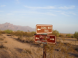
Sand sand and more sand by BEEBEE  Located in the southeast area of Usery Mountain Park. The trail runs from the Spillway trailhead at Signal Butte and McClellan Road and terminates at its north end where it links back up with the Spillway Trail before it reaches the Levee. The Trail can be reached from 3 places. The Spillway Trailhead at McClellan Road. The Signal Wash Trailhead is located in the midpoint of the trail located at Signal Butte Road and Jensen and the north end from the Spillway Trail. Located in the southeast area of Usery Mountain Park. The trail runs from the Spillway trailhead at Signal Butte and McClellan Road and terminates at its north end where it links back up with the Spillway Trail before it reaches the Levee. The Trail can be reached from 3 places. The Spillway Trailhead at McClellan Road. The Signal Wash Trailhead is located in the midpoint of the trail located at Signal Butte Road and Jensen and the north end from the Spillway Trail.The trail is soft loose sand for its total length and is in good condition but receives heavy equestrian traffic and has the road apple problem that many of the trails in Usery have. Also when it has been dry for a while it becomes quite dusty, so when you get a fast-moving group of riders passes you expect to get dusted. The trail is an active wash and heavy rain can flood, but the sides are not very high so it would be easy to get out of the path of moving water. Being a wash the trail is well shaded. At the north end, the trail is wide and becomes quite narrow as it reaches its southern end.
Check out the Official Route and Triplogs. Leave No Trace and +Add a Triplog after your hike to support this local community. One-Way Notice This hike is listed as One-Way. When hiking several trails on a single "hike", log it with a generic name that describes the hike. Then link the trails traveled, check out the example. | |||||||||||||||||||||||||||||||||||||||||||||||||||||||||||||||||||||||||||||||


