Route Editor

| Guide | ♦ | 9 Triplogs | 0 Topics |
details | drive | no permit | forecast | route |
stats |
photos | triplogs | topics | location |
| 15 | 9 | 0 |
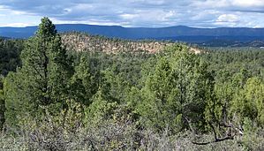
good exercise loop; views by donqcryer   A good exercise hiking loop off of E Phoenix Street and Promontory Way. Best to download GPS track to find and follow, especially on the single-track trail sections. Once on the trail, the single track is flagged (though not on jeep double tracks or PATS.) Joins and leaves PATS Round Valley trail. After rains, mud is super sticky! The first part of the trail from the trailhead to an established Jeep track is well worn and maintained by gnomes and elk, though to keep ATV'ers away, it is somewhat hidden. Go across fire break along a barbed-wire fence, turn L along the edge of fire break and go to weak jeep track, turn R on jeep track - 50' down real flagged and worn trail starts on left hidden by scrub oak. A good exercise hiking loop off of E Phoenix Street and Promontory Way. Best to download GPS track to find and follow, especially on the single-track trail sections. Once on the trail, the single track is flagged (though not on jeep double tracks or PATS.) Joins and leaves PATS Round Valley trail. After rains, mud is super sticky! The first part of the trail from the trailhead to an established Jeep track is well worn and maintained by gnomes and elk, though to keep ATV'ers away, it is somewhat hidden. Go across fire break along a barbed-wire fence, turn L along the edge of fire break and go to weak jeep track, turn R on jeep track - 50' down real flagged and worn trail starts on left hidden by scrub oak.When flagged trail T's onto a well-used Jeep road, turn L. Go L at next weak Y where a single-track trail crosses a small wash; go by a tank (should be on your R; & always has water). Rejoin Jeep 2X track and follow until it T's with PATS Round Valley double track, turn right take PATS down & up to hill crest to an intersection where you & PATS turn right. There are lovely views along this next, somewhat level, 2X stretch. At the next obvious double-track intersection (2X coming in from the R), go R (PATS Round Valley goes straight), follow down to dry wash where 2X will now begin to go uphill, cross wash here, and leave jeep 2X track, turning right and find an off-trail flagging. This next downhill stretch is rocky with no obvious trail except for flags and cairns set by the friendly gnomes. It goes down and crosses a wash, then crosses an obvious elk trail.
Check out the Official Route and Triplogs. Leave No Trace and +Add a Triplog after your hike to support this local community. | ||||||||||||||||||||||||||||||||||||||||||||||||||||||||||||||||||||||||||||||||||||||||||||||||||||||||||||||||||||||||||||||||||||||||||||||||||||||||||||||||||||||||||||||||||