Route Editor

| Guide | ♦ | 14 Triplogs | 0 Topics |
details | drive | no permit | forecast | route |
stats |
photos | triplogs | topics | location |
| 204 | 14 | 0 |
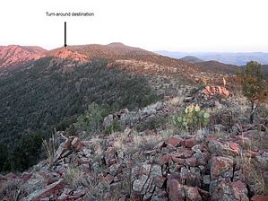
360 degree vistas! by donqcryer   This hike starts at either the E Phoenix Street & Promontory Way Trailhead or PAT's Round Valley trailhead on S Gibson Ct (off of Phoenix Str). This hike starts at either the E Phoenix Street & Promontory Way Trailhead or PAT's Round Valley trailhead on S Gibson Ct (off of Phoenix Str).It hikes along the ridgeline/hilltops and ends at a high rock outcropping, which might be Payson's best 360 views. Over the past few years, this hike has become popular and what was somewhat of a bushwhack following the ridge crest is now a well-established trail from either Gibson TH or the trail intersection with PAT's Round Valley Trail at the saddle.
The destination has rock climbing opportunities and long straight-down 'the end' falls. All sweat equity is rewarded with unbelievable views, sunrises, and sunsets. Throw in red rock, marble and travertine outcroppings, and a Native American look-out, and what more could one ask? This last peak/hill is also at the end of the fire break. Though two more peaks (including the highest - Stewart Peak) loom before Hells Gate, proceeding by bushwhacking can be somewhat futile unless wearing leather chaps - if the cactus doesn't get you, the Cat's Claw will! Others seem to have found ways to those peaks without much trouble, so it may just depend on one's bushwhacking skills. Updated 2017-05-19 Check out the Official Route and Triplogs. Leave No Trace and +Add a Triplog after your hike to support this local community. | |||||||||||||||||||||||||||||||||||||||||||||||||||||||||||||||||||||||||||||||||||||||||||||||||||||||||||||||||||||||||||||||||||||||||||||||||||||||||||||||||||||||||||||||||||||||||||||||||