Route Editor

| Guide | ♦ | 7 Triplogs | 0 Topics |
details | drive | no permit | forecast | route |
stats |
photos | triplogs | topics | location |
| 56 | 7 | 0 |
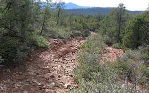
good workout hike with views by donqcryer   This lasso route starts off a new cul-de-sac (not on any current map) off of the new E Phoenix Street extension. It also begins on the PATS Round Valley Trail and follows it to Round Valley, then leaves PATS and goes SE on Gibson Ranch Road before returning uphill on another trail and rejoining PATS back to the trailhead. For the most part, it is all double track (old jeep roads)and a nice long workout hike with views of the Matazal most of the way. Without much shade, it is best to do it early. This is an excellent mountain bike loop and I would recommend doing it in reverse of how it is posted. Solitude is guaranteed! This lasso route starts off a new cul-de-sac (not on any current map) off of the new E Phoenix Street extension. It also begins on the PATS Round Valley Trail and follows it to Round Valley, then leaves PATS and goes SE on Gibson Ranch Road before returning uphill on another trail and rejoining PATS back to the trailhead. For the most part, it is all double track (old jeep roads)and a nice long workout hike with views of the Matazal most of the way. Without much shade, it is best to do it early. This is an excellent mountain bike loop and I would recommend doing it in reverse of how it is posted. Solitude is guaranteed!The first part is the toughest. After a modest climb, the trail goes steeply straight up to the top of the ridge, complicated by loose footings of hard head rocks (This section is open to ATV's) After cresting the ridge through a saddle, the trail has a modest decline down to a wash, where again we begin a long climb. Close to the crest of the hill, go right, continuing on PATS (marked.) (You will return to this intersection coming up from the SE completing the loop part of the lasso here...) The trail is mostly level here for a mile and has great views of the Rim and Matazals. Soon the trail begins a long modest descent to Round Valley and T's with Gibson Ranch Road. Go L along the road for about .4 miles and find an established jeep trail on your L. This is where dues will be paid and last night's pizza will be burned off - a long, but modest climb back up the hill. Be aware, many many trails are traversing all through this area, and on this section, a GPS would be more than helpful. The last part is a little up & down and passes an all-season tank, before completing the loop at the previously mentioned intersection and retracing the last section down, up, and down to the trailhead. Enjoy the serenity and solitude!
Check out the Official Route and Triplogs. Leave No Trace and +Add a Triplog after your hike to support this local community. | ||||||||||||||||||||||||||||||||||||||||||||||||||||||||||||||||||||||||||||||||||