Route Editor

| Guide | ♦ | 1 Triplog | 0 Topics |
details | drive | no permit | forecast | route |
stats |
photos | triplog | topics | location |
| 8 | 1 | 0 |
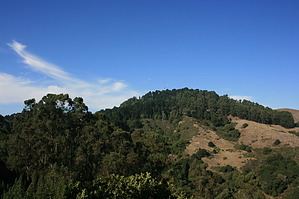
Oakland Hills Gem by JimmyLyding The hike starts by heading uphill/east from the parking area and visitors center, and you have 3 choices. The southernmost route is a road, and 2 short trails head uphill north of that road. The northernmost route is the most interesting. The northernmost route winds through a young eucalyptus forest for .24 mile until it joins with the Skyline Trail which is the middle route up from the visitors center. The Skyline Trail (part of the Bay Area Ridge Trail system) turns due south just below a water tank, crosses the road after 0.18 miles, and descends into the depth of the San Leandro Creek drainage.
After crossing San Leandro Creek 0.81 miles down from the road you immediately start ascending the west side of the canyon. There is an access point for Huckleberry 0.22 miles south of the crossing off of Pinehurst Road. Turn right to remain on the Skyline Trail, and there's another junction 0.12 mile up from the creek. You've now reached the Huckleberry Path. You can turn left to continue on Skyline as it runs concurrently with Huckleberry Path or right to head 0.32 miles up to the Huckleberry Staging Area off of Skyline Blvd. I went right, and there's a picnic bench at the staging area that's a nice spot for a break. There is a vault toilet here as well. The Huckleberry Path forms a loop from the staging area, and you want to take the upper portion to continue the hike. This stretch is pleasant and flat as it winds its way through the dense bay forest, and has intermittent views of Round Top to the north on the other side of San Leandro Creek. You reach another junction with the Skyline Trail approximately 3/4 mile from the staging area. Turn left to return to the junction just above San Leandro Creek or right to head into Redwood Regional Park. Returning to the trailhead from this point leads to a 5-mile hike, but Redwood Regional Park is worth checking out, and is an easy way to add mileage to your trip. The return trip is highlighted by a steep climb out of the canyon back to the road along the south flank of Round Top. Check out the Official Route and Triplog. Leave No Trace and +Add a Triplog after your hike to support this local community. | |||||||||||||||||||||||||||||||||||||||||||||||||||||||||||||||||||||||||||||||||||||