Route Editor

| Guide | ♦ | 14 Triplogs | 0 Topics |
details | drive | no permit | forecast | route |
stats |
photos | triplogs | topics | location |
| 108 | 14 | 0 |
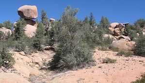
Off the Beaten Track Scenic Adventure by donqcryer   Overview OverviewSedona has its well-known Red Rocks, but few know how beautiful Payson's Pink Rocks can be. Stewart's Pocket area may very well rival Sedona for its scenic beauty. Flanked by Stewart Ridge on the South and the Mogollon Rim on the north it not only contains the amazing boulder formations of Granite Dells, but numerous peaks or knolls, many topped by pink rocks, and many perfect cones and plenty steep (most noteworthy is Monument Peak). Add a year-round stream (Stewart)and others, and springs and the riparian areas are a magnet for wildlife. This partial OFF TRAIL loop shows off the best of the area. It goes by a car-size balancing rock and a truck-size boulder where the wash goes underneath. This loop uses parts of the PATS Cypress, Boulders, and Monument Peak trails and connects them all so trail length can be increased substantially if so desired. Best of all you will be by yourself and no ATVs! Warning Most sections are OFF TRAIL. I love real hiking trails, single tracks that meander. I am not so fond of jeep /ATV roads. Many times they become so rutted or slippery on steep grades from loose gravel on packed hardpan. It is like walking on ball bearings on a steel plate. So this route follows washes up over saddles and washes back down. Though flagged and cairn-ed sporadically, a GPS is advised. Given the off-trail aspects and being in washes, be aware of rattlers...
Starting at the E Phoenix Street cul-de-sac PATS Cypress TH, head down Cypress to Boulders North and follow it down to its lowest point where it crosses Stewart Creek for the last time before a steep rise. Go L off-trail (see pic) and scramble around and through and down the massive boulder field following the creek. Spend time here, and explore every nook and cranny - it is fabulous. Make sure to find the amazing cork-screw erosion the creek made in a granite rock lip. After leaving the boulder area and where the stream bed flattens and where you can clearly see a saddle to your left, find a cairn and flagging and/or a small wash that heads to the top of the saddle. At the top, find a knoll to your North with large boulders, you will be passing that knoll with it on your right. Find a wash going down, and maybe the flagging and some cairns. The wash merges with a larger wash and continues downs generally heading for the boulder knoll. Close to a large Balancing Rock (you will know it when you see it..), the wash merges with another wash at a Y. Make a 160 and go up this new wash. The intersection is flagged and with a cairn. You can also see Monument Peak in the distance and you should be aiming a little to the Right of it. As you come closer to the Balancing Rock the wash disappears beneath a truck-size boulder, there is a small 4' high passage to the right for you to duck under, then go hard left to get back in the wash and continue following upwards. The wash splits a few places. Keep heading for the next saddle. There are sporadic flags and or cairns. Do not be surprised by the increasing amounts of litter! At the top of the saddle, there is an old jeep track, turn right. Welcome to one of many of Payson podunk's dumping grounds! As you will see, this section of jeep trails is now blocked off to try to stop further dumping. I am sure these types of people will just find another spot in the NF! UGH! Anyway, try to block out the blight and go 100' down and turn left over a large log and the blocking berm at the intersection with Granite Dells Road (gravel). Cross over the road and a little to your left find a moderate wash and go down in it. Follow this wash until it comes to a well-used ATV/jeep road/trail, right after crossing a creek (The last 50' is blocked with scrub, etc - just find a way around the thicket...) This track is the PATS Monument Peak Loop. Go left. At the next jeep / ATV intersection where PATS MP goes straight, go L on a spur road the goes back to Granite Dells Road. Go R on Granite Dells. Go up a 100' or so and enter a major wash (go L) at the obvious road culvert/bridge. Follow this wash up for almost a mile. This wash is also the boundary for the FS fire break (cut on the right, no cutting on L, so when the wash splits, you know which fork to take. As you approach the end of the wash right at Cypress Trail (N), there is a cairn and flagging. Go L over the saddle. (If you want a faster way back - hop on Cypress and take that back...) Follow flagging, cairns, etc down into a small wash and follow this wash down. It will intersect with Cypress. Get on & off Cypress, getting back in the wash in 50'. Follow down until a wash comes it from the right. Take a 160 and follow this wash up and over a saddle (You will see Cypress here 100' on your R..) Head L down between knolls and then R between knolls and rejoin Cypress for about 100'. Leave Cypress at the next wash on your L. Follow wash down until you come to a year-round spring / grassy area (obvious deer/elk, etc watering hole!) Exit the wash to R and climb uphill, cross over hill and go down to a new wash (and wash intersection - cairned). Follow this wash up until it hits Cypress. Go L on Cypress and follow back 0.3 miles to the TH. Water Sources numerous Camping Yes (NF) Check out the Official Route and Triplogs. Leave No Trace and +Add a Triplog after your hike to support this local community. | |||||||||||||||||||||||||||||||||||||||||||||||||||||||||||||||||||||||||||||||||||||||||||||||||||||||||||||||||||||||||||||||||||||||||||||||||||||||||||||||||||||||||||||||||||||||||||