Route Editor

| Guide | ♦ | 2 Triplogs | 0 Topics |
details | drive | no permit | forecast | route |
stats |
photos | triplogs | topics | location |
| 20 | 2 | 0 |
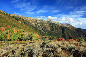
Warning the ridge line to the summit and the peaks are completely exposed and above timberline. This is not th place to be during a storm.
Once you achieve Andrew's Ridge, you will continue to hike along the ridge or just off to the north side for a couple of miles, again occasionally passing through forest, now composed of conifers and some aspen. You will also cross over a few prominent drainages. Finally just a bit over 4 miles in to the hike you come to an unsigned trail intersection in the trees. An obvious trail breaks slightly right and down (the continuation of Nebo Bench). A second trail goes generally straight and slightly up (the summit ridge trail - your choice) and a third faint use path heads almost straight up/left. Go straight onto the summit ridge trail. The next half mile switchbacks and climbs wildly up to the summit ridge line through open grasses and flowers. Once you hit the summit ridge line there is a sign pointing to the right, indicating mighty Mt. Nebo lies ahead. Turn right onto the obvious trail. The summit of South Nebo lies about 1.8 miles up the ridge line, which is now basically entirely above timberline. The views of the Nebo peaks are fantastic, and from the ridge you can see almost forever, it seems, into the Wasatch and also over Utah Lake. The hike along the ridge to the southern summit gradually increases in steepness and is across talus most of the way but there is a pretty easy trail to follow. At a few points the trail splits, but always rejoins so it doesn't really matter which way you go. About 0.5 miles shy of the final summit push to come across a small alpine/glaciated type of flat that is really quite awesome, good place for a rest before the final last little steep section to the southern Nebo summit where awe inspiring views await over the Mt. Nebo Wilderness, Middle and Northern Nebo Summits, Santaquin Peak and Utah Lake area. Incredibly steep glacial basins drop down immediately to the east. Return the way you came. Check out the Official Route and Triplogs. Note This is a difficult hike. It would be insane to attempt this entire hike without prior experience hiking. Leave No Trace and +Add a Triplog after your hike to support this local community. | |||||||||||||||||||||||||||||||||||||||||||||||||||||||||||||||||||||||||||||||||||||||||||||||||||||