Route Editor

| Guide | ♦ | 6 Triplogs | 1 Topic |
details | drive | no permit | forecast | 🔥 route |
stats |
photos | triplogs | topic | location |
| 113 | 6 | 1 |
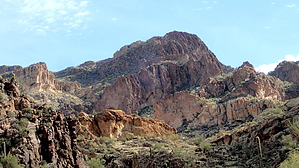
Route to ruins, dry or wet, your choice by CannondaleKid  Overview OverviewThe ruins (described elsewhere as defensive) are on a peak overlooking the Salt River across from Redmond Flat. Due to the location of the ruins, there are several options for your actual route. If you aren't a rafter there are two basic approaches, along the ridge or up from the creek. After having tried both, in my estimation, the ridge approach is easier and quicker with plenty of photo opportunities of the surrounding area. If you choose to follow the creek it's much harder if you try to stay dry. If you don't mind walking in the creek 90% of the time it's kind of fun and you avoid much of the thorny brush. It's possible to do this hike out-and-back overland in 3 hours, but plan on at least 4 hours if you want to spend some time wandering around the ruins and taking plenty of photos. Add another hour or two if you decide to drop down and spend some time along the Salt River, maybe even walk across depending on season and flow. If you want more variety I'd recommend the ridge approach to the ruins then starting from the 'Gateway' (see GPS route) drop down to Coon Creek and follow it on the return.
See the Coon Creek - Lower Canyon Trail description for some historical context. Hike Begin your hike from the trailhead parking lot just off Cherry Creek Road. (See directions for Coon Creek - Lower Canyon Trail) As noted in the overview you can hike it like the warning to Paul Revere, one if by land, two if by sea (creek). If your main interest and goal are the ruins, download my very simple 6 point GPS route and follow the general route, wavering from it as you wish to follow the terrain you prefer or to check out some areas of interest along the way. As you approach your destination plenty of photo opportunities will present themselves. Once you catch a glimpse of the lower wall of the ruins your anticipation will grow and you'll eagerly pick up speed. If you happen to waver a bit west of the track after the 'Gateway' (see my 10/24/11 photoset for a shot of the gateway) look to your right in an open area and you may find you're on candid camera... there is a game video cam attached to a fence post. As you make your last approach you will want to stay to the west (your right) of the fence as the greatest portion of the ruins are on that side. When you start your easy climb into the ruins you may want to keep track of how many levels of terracing there is. (I didn't keep track, so I can only guess there are at least four, possibly as many as 6 levels.) Take your time wandering around and catching the awesome views of the Salt River, Redmond Flat, and the area along Coon Creek. For your return, you can follow the same general route along the ridge or starting from the gateway, angle NNW down to the creek, and follow it back. To spend the most time in the creek on the return, continue south from the ruins to the lowest saddle just before the last outcrop next to the Salt River then turn hard right and drop NW down to a deeper part of Coon Creek. Optional If you have plenty of time, you're into a bit more adventure and don't mind carefully dropping down some steep terrain as well as the mandatory effort for the return trip back up, by all means, do so. While I believe it's possible to continue south from the ruins to drop down a narrow gorge, it looked too loose for me so I headed back up to the ruins and north back down to the saddle then took a beeline toward the Salt River. Just beware that when you hit the level of the shoreline, due to the choking vegetation (tamarisk?) it won't be a simple walk to reach the river. For me it was a combination of clipping the worst of the thorny brush, pushing through the less-sharp brush, and even crawling on my stomach and I finally made the shore. Gate Policy: If a gate is closed upon arrival, leave it closed after you go through. If it is open, leave it open. Leaving a closed gate open may put cattle in danger. Closing an open gate may cut them off from water. Please be respectful, leave gates as found. The exception is signage on the gate directing you otherwise. Check out the Official Route and Triplogs. Leave No Trace and +Add a Triplog after your hike to support this local community. | |||||||||||||||||||||||||||||||||||||||||||||||||||||||||||||||||||||||||||||||||||||||||||||||||||||||||