Route Editor

| Guide | ♦ | 190 Triplogs | 0 Topics |
details | drive | no permit | forecast | route |
stats |
photos | triplogs | topics | location |
| 411 | 190 | 0 |
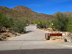
.. Local & Distant 360 degree Views from 3069ft .. by Grasshopper  Overview OverviewThis hike is one of several popular day hikes in the Northeast Scottsdale- "McDowell Sonoran Preserve". There are four main trailhead access points in this preserve off Via Linda Street that connect with the north then east-to-west Sunrise Trail all of which offer a hiking option to summit Sunrise Peak at 3069 feet. This "Sunrise Peak from 145th Street" hike description is the fourth and last trailhead option when driving east on Via Linda Street in Scottsdale. Warning This hike is mostly full sun exposure from beginning to end and also exposed to threatening weather conditions, so beware and plan accordingly. Also, even though this trailhead has adequate parking, and appears to be in a fairly secure area, it does not have bathroom facilities.
From this trailhead, you begin hiking on the popular Sunrise Trail which officially begins at this trailhead and travels north, then east to west ending 4.4 miles into the preserve at the intersection with the Lost Dog Wash Trail. This first 1.6-mile hike on the Sunrise Trail to intersect the first spur trail segment to Sunrise Peak is well maintained, five-foot-wide, smooth-gravel trail which traverses and switchbacks up a moderate grade to a high saddle at 1.6 miles in. Just west of this saddle in your signed left turn (NW) spur trail heading uphill at a much steeper grade and more rocky 0.3 miles to summit Sunrise Peak at its 3069ft west end highpoint with near and distant views south, west and north into more of the McDowell Sonoran Preserve. After spending time at this highpoint it is highly recommended that you hike the very short-use trail route east along the summit ridge to the eastern summit end. On a clear view day, you will enjoy excellent distant views of the famous Fountain Hills high water fountain (which is active daily at the top of the hour for fifteen minutes), and views east past Fountain Hills to include the Four Peaks/Four Peaks Wilderness and grand views southeast into the Superstition Wilderness. Begin the exit down from the summit initially using the same steep route for ~0.2 miles to connect with the not yet hiked spur trail heading NW (left turn) down to connect again with the Sunrise Trail. Once at this intersection with the Sunrise Trail, turn right (east) and continue ~1.8 miles back to your TH-Parking/Start location (Note: Posted to this hike description, please also view "official" GPS Route with information notes for more details). Shuttle It should also be noted that this hike starting or ending from the 145th Street TH combined with any of the other Via Linda Street TH options (from the 124th St-Lost Dog Wash, 128th St., or 136th St.) would make for an excellent car shuttle hike opportunity with minimal driving time-distances to retrieve your other shuttle vehicle. Water Sources The only water source available on this hiking route is at the hike start/end where a water fountain/cooler is located for public use. Check out the Official Route and Triplogs. Leave No Trace and +Add a Triplog after your hike to support this local community. | ||||||||||||||||||||||||||||||||||||||||||||||||||||||||||||||||||||||||||||||||||||||||||||||||||||||||||||||||||||||||||||||||||||||||||||||||||||||||||||||||||||||||||||||||||||