 Route Editor

| Guide | ♦ | 84 Triplogs | 0 Topics |
details | drive | no permit | forecast | map |
stats |
photos | triplogs | topics | location |
| 590 | 84 | 0 |
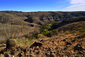
 Overview OverviewBLM - The 23,000-acre Gila Box Riparian National Conservation Area is truly an oasis in the desert. It has four perennial waterways - the Gila and San Francisco rivers and Bonita and Eagle creeks, which are the lifeline for this remarkable place. The Gila River canyon section, known as the Gila Box, comprises patchy mesquite woodlands, mature cottonwoods, sandy beaches, and grand buff-colored cliffs. Bonita Creek, famous for birdwatching, hiking, and picnicking, is lined with large cottonwoods, sycamores, and willows. The perennial creek and riparian vegetation make this a cool year-round desert oasis. Cliff dwellings, historic homesteads, Rocky Mountain bighorn sheep, and over 200 species of birds make this year-round watery desert refuge worth the short drive from Safford. Check out the Triplogs. Leave No Trace and +Add a Triplog after your hike to support this local community. One-Way Notice This hike is listed as One-Way. When hiking several trails on a single "hike", log it with a generic name that describes the hike. Then link the trails traveled, check out the example. | |||||||||||||||||||||||||||||||||||||||||||||||||||||||||||||||||||||||||||||||||||||||||||||||||||||||||||||||||||||||||||||||||||||||||||||||||


