Route Editor

| Guide | ♦ | 6 Triplogs | 1 Topic |
details | drive | permit | forecast | 🔥 route |
stats |
photos | triplogs | topic | location |
| 198 | 6 | 1 |
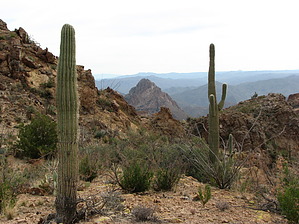
Heart-of-the-Wilderness by CannondaleKid  Take a good look at a topo map of the White Canyon Wilderness, and you may notice a sizeable heart-shaped plateau virtually surrounded by steep cliffs. While many hikers have traversed up & down the canyon to the east (see White Canyon canyoneering description) or have traversed the GET#3 (was AZT#16 at the time of this description) in the canyon to the west, very few appear to have ventured up onto the roughly 2-square-mile upper plateau. Probably the most common reason not many have done so is the intimidating cliffs. But after some research, poring over topo maps as well as boots... whoops, Teva's-on-the-ground hiking of White Canyon, we decided to give it a shot. Take a good look at a topo map of the White Canyon Wilderness, and you may notice a sizeable heart-shaped plateau virtually surrounded by steep cliffs. While many hikers have traversed up & down the canyon to the east (see White Canyon canyoneering description) or have traversed the GET#3 (was AZT#16 at the time of this description) in the canyon to the west, very few appear to have ventured up onto the roughly 2-square-mile upper plateau. Probably the most common reason not many have done so is the intimidating cliffs. But after some research, poring over topo maps as well as boots... whoops, Teva's-on-the-ground hiking of White Canyon, we decided to give it a shot.The only thing I knew for sure is that there was relatively easy access to the upper mesa from the far-right ventricle of the heart, and the highest peak was on the far upper-left edge of the left ventricle. So with plenty of guess-and-by-gosh thinking, I hoped to find reasonable access near the highest point, Peak 3660. So with just that much data in-hand, we set out to: 1. find another way up, 2. bag Peak 3660, 3. cover as much ground up top, and 4. finally try to locate another way down just below the right ventricle.
Now it was a matter of, where do we explore first, how far do we go, and do we shoot for the known-way-down, or do we seek one other possibility down? We settled for continuing across the heart center following a descending-in-steps ridgeline, seeking (and failing) the shortest route down and ultimately heading back up north-east to the known exit. Then it was merely following... ok, so it was more like not-quite-so-simple boulder-hopping our way back to Battle Axe Road and walking west back to the car. One last photo of the base of the heart from the car, and we headed home. With just a hint of a taste of what still lies up there waiting for us to explore, we are already planning the next trip. Check out the Official Route and Triplogs. Note This is a moderately difficult hike. Leave No Trace and +Add a Triplog after your hike to support this local community. | |||||||||||||||||||||||||||||||||||||||||||||||||||||||||||||||||||||||||||||||||||||||||||||||||||||||||||||||||||||||||||||||||||||||||||||||||||||||||||||||||||||||||||||||