| Guide | ♦ | 31 Triplogs | 0 Topics |
details | drive | permit | forecast | route |
stats |
photos | triplogs | topics | location |
| 249 | 31 | 0 |
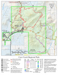
No log ride on this Flume by mt98dew  Overview OverviewThis is one of 8 trails in the Cave Creek Regional Park. The Flume Trail is an interior trail, so additional hiking is needed in order to reach the start of this trail. The Flume Trail is most easily reached by the Slate Trail. The TH for these trails has space for almost 40 cars. Just to the south of this parking, there is additional parking for horse trailers. There are restrooms at the TH, but no water. There are also a handful of picnic tables and grills to the north of the TH. As mentioned, there is no water at this TH, so come prepared and plan accordingly. Hike To access the Flume Trail take the Slate Trail about 0.9 miles east. There is a signed juncture and the Flume Trail takes off in a southward direction. The Flume Trail can best be broken down into four distinct segments. The first segment is composed of hills and washes. This segment lasts for about 0.65 miles and generally follows an eastward direction. During this time the views are limited initially by the up and down nature of the landscape and the rising hills to both the north and south. Approximately 0.4 miles in you’ll reach the top of one of the higher hills and are then able to get a good view to the east for the first time. In my mind this stretch is slightly annoying due to the loose rockiness of the trail and because the inclines and declines are taken in a very straightforward manner. At about 0.65 miles the trail flattens out and in 0.15 miles enters a wash.
At 1.55 the trail reaches its fourth distinct section and its most annoying section. At this point, the trail comes to a four-way juncture. There is a solid single track that continues to the south. There is a road that heads east down into the wash. And this same road also takes off to the west, with open desert and homes to the south and the mountain that the Flume Trail has been circling to the north. The signage at this juncture is not clear but the official Flume Trail follows the road to the west. This stretch is flat, straight, rocky, and unimaginative. This dual track runs for about 0.8 miles before ending at a gate. The road continues past this gate, but there is a sign indicating that the Flume Trail ends and/or begins at this gated intersection. (I have seen cars parked on this road and seen people hiking in from this intersection. However, it is not an official trailhead). The Flume Trail is just over 2.37 miles long. However, there are 0.9 miles of additional hiking needed (Slate Trail) to reach the beginning of the Flume Trail. That makes this a 3.27-mile hike one way. The options for returning to the trailhead are limited. The most obvious is to return the way you came for about a 6.5-mile hike. The other option is to take one of the user trails that drop down into the Cave Creek Wash or, at the 4-way junction follow the user trail south. There are numerous user trails that branch off of this, some of which even connect to the Sonoran North Preserve. Note The statistics (time, distance, elevation) for this trail are only for the Flume Trail going in one direction and do include stats for other trails that may be used in association with this hike. Gate Policy: If a gate is closed upon arrival, leave it closed after you go through. If it is open, leave it open. Leaving a closed gate open may put cattle in danger. Closing an open gate may cut them off from water. Please be respectful, leave gates as found. The exception is signage on the gate directing you otherwise. Check out the Official Route and Triplogs. Leave No Trace and +Add a Triplog after your hike to support this local community. One-Way Notice This hike is listed as One-Way. When hiking several trails on a single "hike", log it with a generic name that describes the hike. Then link the trails traveled, check out the example. | ||||||||||||||||||||||||||||||||||||||||||||||||||||||||||||||||||||||||||||||||||||||||||||||||||||||||||||||||||||||||||||||||||||||||||||||||||||||||||||||||||||||||||
 Route Editor


