Route Editor

| Guide | ♦ | 2 Triplogs | 2 Topics |
details | drive | permit | forecast | 🔥 route |
stats |
photos | triplogs | topics | location |
| 82 | 2 | 2 |
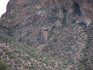
Slots & Caves by CannondaleKid  After a great deal of research about the area bounded on the north by the US 60, on the east by SR 177, along the south by the Gila River, and on the west by SR 79, I haven't found any specific name for either the mountain, the canyon immediately below this cave, or the cave itself, so I'm just going to call this hike "The Cave". I thought of "The Window Cave" because there is a window out the back, but the description is long enough already. After a great deal of research about the area bounded on the north by the US 60, on the east by SR 177, along the south by the Gila River, and on the west by SR 79, I haven't found any specific name for either the mountain, the canyon immediately below this cave, or the cave itself, so I'm just going to call this hike "The Cave". I thought of "The Window Cave" because there is a window out the back, but the description is long enough already.I had made a note of this cave some months back and added it to my list for a future hiking destination. But during my 4x4 recon trip on 12/5, I reached an overlook less than half a mile across a deep wash from it, and appearing to be Cookie Monster with his mouth open wide, and I decided it would be our next hike. The only problem with approaching it from the overlook was the 2+ hour serious 4x4 tooth-rattling drive to get there, and Tracey wasn't too keen on traversing all the rough, steep, and rocky areas to get there. Coming from the Gila River was out due to it flowing again, so the only other option was coming in from Battle Axe Road. Although the highway driving distance was longer, once on dirt, it was about the same, but at least one could drive a stock 4x4 in from Battle Axe. The road isn't nearly as bad and saves about an hour. Although our start point was at N33 07.166 W111 08.743, very few vehicles would make it the last few hundred yards, so you'll note the TH is just over a quarter mile south, which means the hike will be about 0.6 miles longer than the GPS track for our hike.
Once out of the wash, our loop took us north and east around the mountain, then back south along a short concurrent section of the Arizona Trail (a new section just completed), continuing along what was the Red Mountain Mine Road a long time ago. Today only VERY serious rock crawlers could hope to traverse it. Check out the Official Route and Triplogs. Note This is a moderately difficult hike. Leave No Trace and +Add a Triplog after your hike to support this local community. | ||||||||||||||||||||||||||||||||||||||||||||||||||||||||||||||||||||||||||||||||||||||||||||||