Route Editor

| Guide | ♦ | 4 Triplogs | 2 Topics |
details | drive | permit | forecast | 🔥 route |
stats |
photos | triplogs | topics | location |
| 140 | 4 | 2 |
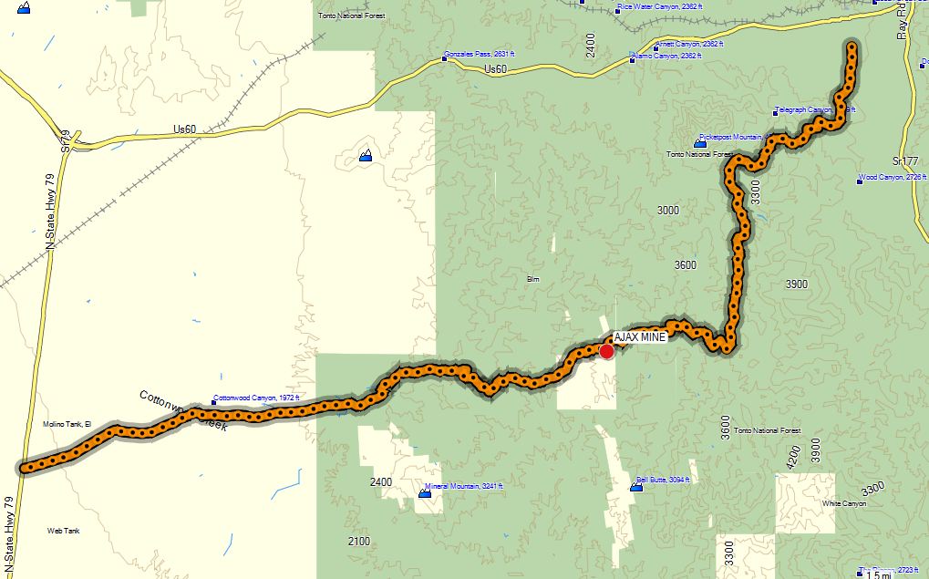
The Road to Pb-Cu-Ag-Au by CannondaleKid   Yes, you are correct, the TH coordinates are for neither the east nor west TH but the actual mine location itself. Yes, you are correct, the TH coordinates are for neither the east nor west TH but the actual mine location itself.The Ajax Mine was an underground mine only in use for two years from 1915 to 1916. It produced Pb-Cu-Ag-Au, which is lead, copper, silver, and gold for those who don't remember (or never learned) the element table.
NOTE: Since I usually start in Superior this description will begin at the Superior High School and all mileages listed will be the distance from there. Drive south for 1.4 miles until you come to a fork in the road. Bear right at the fork and you will now be on Telegraph Canyon Rd. Shortly after turning onto Telegraph Canyon Road, you will come to another fork. Either way can be used but on this occasion, I took the right fork and found to our delight it avoided the deeper and rockier wash which probably would have been impassible with the Pathfinder I was driving today. You will travel by a large bowl in the hillside to your left where it is a favorite of the shooting. Now begins the rough and rocky road that you will be ascending or descending almost constantly until you reach the Ajax Mine. 3 Miles: The road passes over the first of several cattle guards, this one requiring a bit of extra clearance due to being a stepped one. Right after the guard, the road starts winding around the 'back' side of Picketpost Mountain, and all along this part of the drive, you will be treated to constantly-changing yet ever-beautiful views of Picketpost. Along here you will experience a completely different perspective of the familiar peak. 3.5 Miles: Another great vantage point of Picketpost. With the sun momentarily peeking through the overcast we were treated to a wide, almost flat rainbow across Picketpost. 3.6 Miles: The road descends into and travels concurrently along a wash before starting to turn southward away from Picketpost. On this rainy day (with rain the day before as well) the wash was running but with the rocky ground, we had no problem with traction. 3.9 Miles: This is the closest you will get to Picketpost on the whole trip, so if you want some close-ups this is the spot. As the road leads south away from Picketpost it follows a wash with ever-larger rocks to navigate around and/or over. My Samurai ate this section up like nothing back in July, but the Pathfinder being lower, longer, and wider made for a real challenge. 4-5 Miles: This area will be a constant challenge of picking your way through washes, around and/or over rocks but the ever-changing scenery is well worth it. 5.1 Miles: Looking back behind you this will be the last opportunity for a shot of Picketpost for the next 3 miles. 5.5 Miles: Right where the road crosses the center of the wash be sure to take a look at the 'blood' rock in the wash. 6.5 Miles: As the road climbs along and above the wash, if you look down to the wash you will see a rectangular concrete water tank. 6.8 Miles: The Arizona Trail crosses the road on its way between Picketpost and the White Canyon area. 7-8 Miles: The road will meander through rough and rocky terrain along with some steep climbs. On this rainy day (and after the previous day of rain) there were several rock slides we had to stop and clear before passing. 8 Miles: At 3773' this is the highest point of the drive where you will be treated to an awesome view north to Picketpost. Within 600' of the height of Picketpost, just 3 miles away one feels like we are at the same height. On this overcast day, we caught a glimpse of bright sunlight hitting the pure white snow on Four Peaks. Weaver's Needle could also be seen over to the left. From here the road gets very narrow so some of the sharp turn with steep drops just feet from the vehicle make you pay close attention, so let the passenger do the sightseeing and tell you when a good shot presents itself. 8.2 Miles: Now begins the steep descent down to the Ajax Mine. After the rains over the last two days, this section was in pretty bad shape with large washed-out sections that made it necessary to straddle the center of the 'berm' that was left usually on one side or the other of the original road. 8.7 Miles: The Ajax Mine finally comes into view, albeit about a mile-and-a-half away. With a good zoom on your camera, you can get a pretty close shot of it from a point some 800' higher than the mine. Take your last shots of Picketpost, Four Peaks, Weaver's Needle, and the rest of the Supes now because the descent happens fast. 8.7-10 Miles: Very steep, winding down a rough and treacherous narrow road to the mine. 10.1 Miles: Ajax Mine. Upon reaching the mine it's time to take a well-deserved break to get out and stretch your legs. One tip, if you don't drive up the last 300', you definitely will be stretching your hammies. The climb may be short but it's steep. Take your time to wander around the mine but be careful, between people shooting at the walls and the wear-and-tear of time they could fall at any moment. 10-12 Miles: Again the rough narrow road winds along through several washed-out areas where careful tire placement is in order. 12 Miles: The road passes by a windmill and a large water reservoir. Although the windmill is old, the well is new, being drilled when I passed through here in July of this year. Once the well was drilled a new concrete pad was poured and the old windmill was set on it and put back in use. The windmill blades are pretty well shot-up but it was spinning nicely in the wind on this day. 12-21 Miles (The end at SR 79): Due to the road being graded and filled in to allow the large well-drilling truck out this far, the rest of the road out to SR 70 is still pretty decent. If it isn't wet or muddy you could probably make it in a 2WD with reasonable clearance. 13 Miles: You are now on Cottonwood Canyon Road. Unless you are in a rock crawler or don't care about body damage, stick to the main road. 14 Miles: The road passes a kiosk overlooking petroglyphs on the canyon walls across the wash below. When rock crawlers are about, this provides a great vantage point to watch them break their machines. The first time we were out here over a year ago that's exactly what we saw... vehicles breaking in the worst spot. 16-21 Miles: From here out to SR 79 the road is wide and flat so it's a matter of how fast you are comfortable on a dirt road. On this day with no dust to be raised 45-50 mph was just about right.
Check out the Official Route and Triplogs. Leave No Trace and +Add a Triplog after your 4x4 trip to support this local community. | |||||||||||||||||||||||||||||||||||||||||||||||||||||||||||||||||||||||||||||||||||||||||||||||||||||||