|
Western Vista Trail - Sonoran Pre...
|
10.28 mi
1,680 ft |
 |
|
Great Horned Owl Trail - Sonoran ...
|
10.85 mi
1,459 ft |
|
|
Union Dixie and one makes Three
|
11.66 mi
2,175 ft |
|
|
Tortoise Vista Wren GO Lasso
|
6.24 mi
660 ft |
|
|
Tortoise UP Loop plus - Valle Dixie
|
7.81 mi
1,077 ft |
|
|
Union Peak Trail - Sonoran Preserve
|
6.76 mi
1,049 ft |
|
| Great Horned Owl Trail - Sonoran ...
|
10.28 mi
1,162 ft |
|
|
|
Union Peak and Loop
|
7.74 mi
1,069 ft |
|
|
Penance Hike - Union Hills Loop
|
7.05 mi
933 ft |
|
|
Tortoise Owl Union Cactus Valle H...
|
7.28 mi
1,033 ft |
|
|
Union Peak Loop plus
|
7.49 mi
1,097 ft |
|
|
Union-Dixie-Western Vista
|
11.32 mi
1,894 ft |
|
|
Phoenix Sonoran Preserve Loop Union
|
10.93 mi
1,708 ft |
|
|
Desert - Union - Dixie Mountain Loop
|
9.02 mi
1,437 ft |
|
| Hawk's Nest Trail - Sonoran Preserve
|
7.01 mi
961 ft |
|
|
| Great Horned Owl Double Lollipop ...
|
7.91 mi
1,140 ft |
|
|
|
Cactus Wren-Great Horned Owl Loop
|
7.92 mi
900 ft |
|
| Union Peak Loop - PSP - Phoenix
|
8.34 mi
802 ft |
|
|
| Union Peak Trail - Sonoran Preserve
|
7.38 mi
1,021 ft |
|
|
| Pk 2144 and 2111
|
9.81 mi
1,772 ft |
|
|
| Union Hills Loop
|
7.73 mi
1,087 ft |
|
|
| Cactus Wren Loop
|
6.32 mi
734 ft |
|
|
| Cactus Wren-Great Horned Owl Trails
|
7.57 mi
848 ft |
|
|
| Desert Vista to Union Peak Sonora...
|
11.11 mi
1,355 ft |
|
|
| Circle Tank Loop
|
12.71 mi
903 ft |
|
|
| The Union Hills
|
11.32 mi
2,062 ft |
|
|
| Sonoran Preserve - Peak 2383
|
9.9 mi
1,023 ft |
|
|
| Tin Can Tank via Peak 2383
|
10.18 mi
1,147 ft |
|
|
| Great Horned Owl Trail - Sonoran ...
|
8.09 mi
933 ft |
|
|
| Sonoran Preserve to the Dam
|
10.21 mi
1,272 ft |
|
|
| Union Peak Trail - Sonoran Preserve
|
8.57 mi
1,138 ft |
|
|
| The Union Hills
|
10.54 mi
1,748 ft |
|
|
| Phoenix Sonoran Desert Preserve
|
6.37 mi
747 ft |
|
|
| The Union Hills
|
12.76 mi
2,137 ft |
|
|
| Dixie Union Loop - Sonoran Preserve
|
10.78 mi
1,885 ft |
|
|
| Sonoran Preserve to the Dam
|
9.73 mi
1,225 ft |
|
|
| Union Peak Trail - Sonoran Preserve
|
6.91 mi
913 ft |
|
|
| Sonoran Preserve - Peak 2383
|
5.88 mi
952 ft |
|
|
| Sonoran Preserve - Peak 2383
|
7.65 mi
1,056 ft |
|
|
 Route Editor

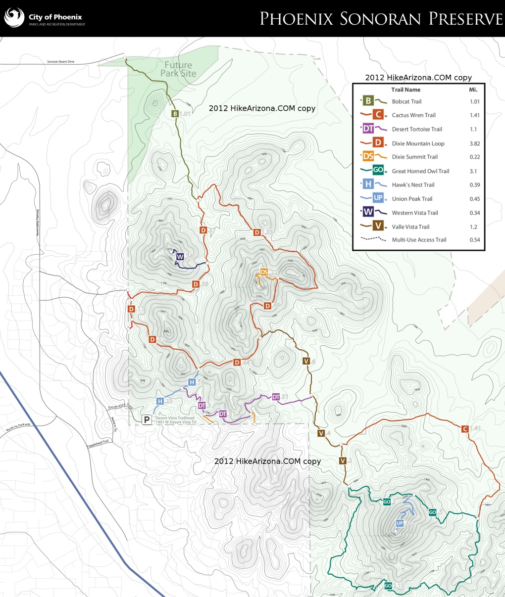
 Access to the beginning of this trail is from the Desert Vista Trailhead via Hawk's Nest Trail, Desert Tortoise Trail and then Valle Vista Trail (a total of 1.77 miles to the beginning). This trail spurs off of the Valle Vista Trail and serves to create a larger, outer loop for the Great Horned Owl Trail.


