 Route Editor

| Guide | ♦ | 8 Triplogs | 1 Topic |
details | drive | no permit | forecast | 🔥 route |
stats |
photos | triplogs | topic | location |
| 46 | 8 | 1 |
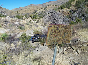
challenging 4WD trip, or a decent hike! by azdesertfather   The Charouleau Gap is one of the best 4WD trips in the Catalinas, but it doesn't make too bad of a horseback ride, mountain bike ride, or shuttle hike either. The Charouleau Gap is one of the best 4WD trips in the Catalinas, but it doesn't make too bad of a horseback ride, mountain bike ride, or shuttle hike either.This scenic route is for 4-wheel drive vehicles only. The road up and over Samaniego Ridge is rough, rocky, and requires good ground clearance as well as excellent traction.
For the northern half of the trip, much of your time is spent down around the Canada del Oro wash and is especially rough in places. The toughest single spot by vehicle is known as The Step (N32.53085 W110.78176); because of the incline it is preferable to drive down it from Oracle; however, many manage to climb up it from the Catalina side. The other tough spot is a quarter-mile stretch known as (yep) the Quarter Mile, which if driving from Oracle starts about a mile south of The Step (around N32.51812 W110.78185) and goes down to the bottom of the elbow in the route. One other place of note is a spot known as the Elevator Shaft (N32.56493 W110.78086), a climb that is long and steep but has a solid surface for vehicles because of past grading. The route also has interesting rock formations, the remains of an old adobe home at a place marked on topo maps as Coronado Camp, and from what I understand some pretty good deer hunting (or observing, if that's your preference). Several primitive roads branch off the Charouleau Gap Road and offer excellent ATV and trail bike riding; according to the Forest Service, vehicles must stay on roads. The Road provides access to two Coronado National Forest trails for hikers and horseback riders, the Samaniego Ridge Trail #7 and the Canada Del Oro Trail #4. As a one-way 4WD trip, the ride is going to take 5-6 hours (as long as you don't bottom out somewhere!). As a hike, it's going to be more like 9 hours. Connecting trails: Along the way, there are two places where trails connect in to continue a journey on foot: - At the bottom of the elbow (and the southern start to the Quarter Mile) is the northern end of the Canada del Oro Trail #4, which runs south and southwest up and around the west side of Mt. Lemmon for about 7.5 miles. You can also reach from here:
- At the top of Charouleau Gap is the start of the Samaniego Ridge Trail #7, a 10.5-mile trail which climbs Samaniego Ridge to the peak and ends near the peak of Mt. Lemmon. From the Samaniego you can connect to the:
History & geology: The Catalina Mountains were formed by a major fault line called Pirate, splitting the range in two and causing the fissure between the Oracle and Samaniego ridges. This split and subsequent erosion created the pronounced alluvial fans seen on the western slopes and the deep chasm that is now home to the flows of the Canada del Oro. Canada del Oro makes its way north around the Samaniego ridge, and then back south to the confluence of the Santa Cruz River. The ancient history of the western slopes of the Catalina mountains starts with the arrival of the Hohokam people from northern Mexico around AD 300, reaching their peak between AD 700 and 1000. The peak years of occupation in the Canada Del Oro were from AD 500-700 before major population units moved to Rillito and eventually the Rincons. Recorded history detailing western civilizations imprint on the Catalinas starts in the 1540s with the expeditions of Don Francisco de Coronado, the famed Spanish explorer, and commander who traveled through much of the southwest in search of gold. Father Kino, who established many of the missions throughout Arizona and California named the mountains Catalina, after St. Catherine in 1697. Famille Charouleau, French pioneers traveled west to this area in the late 19th century, giving the pronounced "gap" along the Samaniego Ridge its name. The Charouleau Gap is more like a saddle, but the name has stuck nonetheless. Check out the Official Route and Triplogs. Note This is a more difficult hike. It would be unwise to attempt this without prior experience hiking. Leave No Trace and +Add a Triplog after your hike to support this local community. One-Way Notice This hike is listed as One-Way. When hiking several trails on a single "hike", log it with a generic name that describes the hike. Then link the trails traveled, check out the example. | ||||||||||||||||||||||||||||||||||||||||||||||||||||||||||||||||||||||||||||||||||||||||||||||||||||||


