Route Editor

| Guide | ♦ | 6 Triplogs | 0 Topics |
details | drive | permit | forecast | route |
stats |
photos | triplogs | topics | location |
| 124 | 6 | 0 |
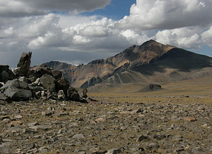
One of twelve by DaddyLongLegs There's something alluring, among serious hikers, about mountains above fourteen thousand feet. In Colorado, there are 51 highly sought after "fourteeners". In California, there are 12, including Mt Whitney, the tallest mountain in the lower 48 states. So, if you're interested in fourteeners, where do you find one that is relatively easy to hike? Try the White Mountains in California's Inyo National Forest. Of the twelve peaks above 14000 in California, White Mountain Peak is the third highest, not far below Mt Whitney and Mt Williamson. Yet, strangely enough, it's probably the easiest "fourteener" to climb in the US. That's because the hike begins at 12000 feet and traverses along a long gentle slope most of the way. The most difficult part is the last two miles, where 11 wide switchbacks take you up the steep climb to the top (about half of your elevation gain).
What's more, even though it's on the opposite side of Owens Valley, White Mountain Peak's elevation makes it a popular warm-up hike for people preparing to do Mount Whitney. However, don't let that fool you. Any hike over fourteen thousand feet will take your breath away if you aren't in condition. Hike The "trailhead" begins at the Barcroft gate at an elevation of 12,000 feet. The same long dirt road which brought you across the White Mountain ridge becomes "a hiker's trail" and meanders its way from the other side of the gate the entire seven-mile trip to the top. Two miles in from the gate, you will come to the University of California, Barcroft Laboratory. Walk straight through, along the road, passing the large gray corrugated metal building and a small coral where you might see twenty head of sheep. Proceed along the road, up the hill slightly to the left, and you will come to a saddle. It is here that you will get your first view of White Mountain Peak, and to your right will be the observatory. The road takes a slight turn to the right and heads downhill for a short way. Then there's a long open stretch as the peak gradually appears to enlarge. Eventually, as you climb the road, you'll pass the White Mountain Wilderness sign. Climbing a bit further, you will come to the top of the massive saddle before the final ascent up the switchbacks. As you begin your descent onto the saddle, you can see the enormity of this mountain. The 11 broad switchbacks lead you to the top, where a tiny shack is used for the White Mountain Research Station. As you begin to climb up from the saddle, the road becomes rockier, and the tan dirt seems to disappear between the cracks. The road is steeper but clearly leads the way to the top. Water Sources None Camping Yes California Fourteeners Wikipedia California Fourteeners List Gate Policy: If a gate is closed upon arrival, leave it closed after you go through. If it is open, leave it open. Leaving a closed gate open may put cattle in danger. Closing an open gate may cut them off from water. Please be respectful, leave gates as found. The exception is signage on the gate directing you otherwise. Check out the Official Route and Triplogs. Note This is a moderately difficult hike. Leave No Trace and +Add a Triplog after your hike to support this local community. | ||||||||||||||||||||||||||||||||||||||||||||||||||||||||||||||||||||||||||||||