2018
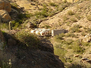
New non camouflaged tanks. Same killer views.
This hike is a lonnnnng 6 miles that require route-finding skills, and perseverance through patches of catclaw. Long pants, long sleeve shirt, and some garden clippers are highly recommended. Leave Fido at home because I guarantee that none of my canine partners would appreciate this hike. 3+ miles of the total distance are easily traveled along the jeep trail through Cottonwood Spring. Once you have left the trail the bushwhack begins and continues until you have descended the boulder-strewn/vegetation-choked waterfall of the canyon which squeezes between the two peaks 2400' in elevation.
Note
The route accompanying this posting DOES NOT go directly to the tanks but instead rises high up the ridge immediately southeast of the tanks. From this high point, a descent down to the tanks seemed infeasible except by backtracking your steps, descending into the wash northeast of peak 2400, and then proceeding back up along the wash to the tanks.
The views from inside both canyons, along the ridge, and nearly everywhere else on this hike are splendid. The Triple Arch is a short hike further northeast of the described route but easily viewed from the least ridge before descending into the canyon. Weaver's Needle. Four Peaks, The Razorback, Razorback Knob, and a host of other landmarks are all within the field of your vision.
WARNING! Hiking and outdoor related sports can be dangerous. Be responsible and prepare for the trip. Study the area you are entering and plan accordingly. Dress for the current and unexpected weather changes. Take plenty of water. Never go alone. Make an itinerary with your plan(s), route(s), destination(s) and expected return time. Give your itinerary to trusted family and/or friends.
Permit $$
None
Directions
Road
High Clearance possible when dry
To hike SR88 (Apache Trail) to FR1356 (Cottonwood Gate). West on 1356 until you reach the intersection with FR3512 (Packsaddle Rd). Turn north on 3512 and drive as far as your vehicle will permit. Hike begins on 3512 and north along Cottonwood Spring.
 Route Editor

 2018
2018