 Route Editor

| Guide | ♦ | 1 Triplog | 1 Topic |
details | drive | permit | forecast | 🔥 route |
stats |
photos | triplog | topic | location |
| 35 | 1 | 1 |
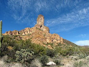
Circling the Thumb by CannondaleKid   Peak 3306 (or what I call 'The Thumb') is readily visible from some distance in many directions but is not easily accessible. Peak 3306 (or what I call 'The Thumb') is readily visible from some distance in many directions but is not easily accessible.Western Approach (Either from Florence via Box/Martinez or SR 79 via Cottonwood/Box/Martinez Canyon Roads) This approach may bring you within 1/4 mile of The Thumb, but it will come at the expense of your vehicle over 20+ miles of the roughest 'road' you'll ever encounter. (Probably the main reason much of the route is so popular with 4x4 fans.) Speaking of vehicles, only experienced drivers with a VERY capable high-clearance 4x4 should attempt this drive. However, I've driven it in less time, figure 2.5 to 3 hours EACH WAY.
(Battle Axe Road from SR 177) This approach will add an extra 4 miles to the hike, but the drive can be done with a much less capable 4x4, even a 2WD with moderate clearance if the road is dry. The drive in on Battle Axe Road is about 11.6 miles and should take less than 2 hours, again each way. The extra hiking miles will all be on a segment of the Arizona Trail #16. Hike The hike is a circumnavigation around Peak 3306, so you can begin the 'loop' part wherever you wish. For the purpose of the hike statistics, I chose the point reachable by vehicle from the west. Not including your time on the AZT#16, if driving in from the east, a mile of the hike will follow the wash/road with the balance of the loop-hike being off-trail. Of the off-trail portion, about 0.8 miles will be spent in a canyon negotiating terrain including thick brush, boulder-hopping, and some reasonably-easy rock climbing, requiring some trail-blazing skills. While it can be a chore at times, the scenery is fantastic. Peak 3306 itself has no confirmed climbs, and that isn't likely to change. Although we did not take the time to do it, if you approach the base from the NNW, you could climb relatively easily up to the base of the sheer cliff walls. Check out the Official Route and Triplog. Leave No Trace and +Add a Triplog after your hike to support this local community. | ||||||||||||||||||||||||||||||||||||||||||||||||||||||||||||||||||||||||||||||||||||||||||||||


