Route Editor

| Guide | ♦ | 4 Triplogs | 0 Topics |
details | drive | permit | forecast | route |
stats |
photos | triplogs | topics | location |
| 68 | 4 | 0 |
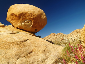
Take a trip to the REAL Indian Hill by PaleoRob Warning: There are many sharp plants along the route. There is no shade, except at Indian Hill, and no water. Take appropriate precautions.
Hike: The hike starts along the Dos Cabezas Road, just southeast of the two large hills near the end of the road. Some folks will park at the end of the road, but there is parking just off the road that doesn't require a scramble to get up to the tracks. After crossing the tracks, a relatively well-worn trail leads off to the southwest. A good map will be useful here. Across the flats, there are two hills: one pointy hill, on the left, and one longer ridge. This longer ridge is labeled "Indian Hill" on the topos, but is not your actual destination. Make a course heading roughly towards the eastern-most (or closest) point on the Indian Hill ridge. This will require crossing an abandoned 4x4 track and weaving through dozens of cholla. Once you reach the easternmost point, you will see a mound of boulders directly to your south. This is the REAL Indian Hill. There are dozens and dozens of morteros scattered around the base of the hill, and many of the sheltered alcoves offer a view of well-preserved pictographs. On the northern side of the REAL Indian Hill is a "yoni", or female fertility icon. A large boulder has been scraped and etched by the Native Americans who inhabited Indian Hill to resemble a vulva. Sit under it at your own risk. There are plenty of neat ancient glimpses into the past to keep you searching for hours. Once you have finished, return to your vehicle the same way you came. If you are looking to get more out of your hike, consider trekking west along the closed 4x4 road. This will take you to an old railroad camp and eventually to another section of track along the San Diego and Eastern's line. Water Sources: NONE Camping: Camping at the trailhead or in the backcountry is allowed. There are better car-camping spots nearby, however. Check out the Official Route and Triplogs. Leave No Trace and +Add a Triplog after your hike to support this local community. | |||||||||||||||||||||||||||||||||||||||||||||||||||||||||||||||||||||||||||||||||||||||||||