Route Editor

| Guide | ♦ | 34 Triplogs | 0 Topics |
details | drive | no permit | forecast | 🔥 route |
stats |
photos | triplogs | topics | location |
| 625 | 34 | 0 |
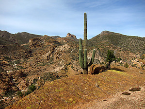
.. Remote-Rugged-Scenic Canyon Adventure .. by Grasshopper   Overview OverviewThis "SW Approach FR319" hiking route into the upper White Canyon Wilderness and the remote upper White Canyon scenic rim area is an excellent alternate hike choice to the posted HAZ "White Canyon" canyoneering hike description for those qualified who enjoy this remote type of off-trail adventure. The first 2.7 hiking miles in (with 0.8 of 2.7mls on 4WD FR2260) is mostly along a primitive hiker/hunter/animal use route within the most upper White Canyon drainage. This route is rock cairned as of this writing with minor overgrowth and minimal bushwhacking required. The balance of the required 1.5-mile hike-in off-trail section to reach the various eleven (11) scenic waypoints listed upper White Canyon "overlooks" requires steady attention to your hiking route. It is highly recommended that you download and follow the "official" 2/15/12 GPS Route posted to this hike description which also includes all key waypoints for this hike. History In 1990 5,800 acres were set aside seven to ten miles south of Superior. The White Canyon Wilderness was formed.
This area is more safely hiked during the early winter to early spring Arizona months due to a general lack of tree and shade cover once in past the 2.7-mile mark. Also, highpoint for this hike at the various upper White Canyon rim overlooks is a maximum of ~3500 feet elevation. Hike From the recommended Park/TH Start location near the end of FR319, the first 2.7 hiking miles in (with 0.8 of 2.7mls on 4WD FR2260) is mostly along a primitive hiker/hunter/animal use route within the most upper White Canyon drainage. This route is rock cairned as of this writing with minor overgrowth and minimal bushwhacking required. The balance of the required 1.5-mile hike-in off-trail section to reach the various eleven (11) scenic waypoint listed in upper White Canyon "overlooks" requires steady attention to your hiking route. It is highly recommended that you download and follow the "official" 2/15/12 GPS Route posted to this hike description which also includes all key reference waypoints for this hike. The best visual and descriptive explanation for this hike description's 4.2-mile hike in is via reviewing the author's 2/15/12 geocoded photoset with detailed captions and tag notes. At this 4.2 mile hike in location (GPS Route ending point), it is recommended rather than backtrack your route in, that at this 4.2-mile ending waypoint location (N33.185883 W111.094491), you hike NE then north first downloading then following the "red" colored GPS Route in this map (following this "red" 2/12/11 actual GPS Route will take you 0.4 miles north to connect with your original hiking route in at the 2.7-mile mark N33.190808 W111.091281). From here you continue hiking east then NE following your previous hiking route in via the upper White Canyon drainage. Water Sources At the end of FR2260 resides perennial "White Water Spring" plus at least one additional perennial unnamed spring along the hiking route within upper White Canyon. (click on pic geocode location for waypoint details). Camping Primitive backpacking campsites are most likely available for setup along this hiking route in but as of this writing, the author does not recall passing any previously established backpack campsites. There is an excellent open area tent camp/car camp (via 4WD vehicle) very close to the end of FR2260 near perennial White Water Spring. (click on pic geocode location for waypoint details). Check out the Official Route and Triplogs. Leave No Trace and +Add a Triplog after your hike to support this local community. | |||||||||||||||||||||||||||||||||||||||||||||||||||||||||||||||||||||||||||||||||||||||||||||||||||||||||||||||||||||||||||||||||||||||||||||||||||||||||||||||||||||||||||||||||||||||||||||||||||||||