Route Editor

| Guide | ♦ | 58 Triplogs | 3 Topics |
details | drive | permit | forecast | route |
stats |
photos | triplogs | topics | location |
| 1.4k | 58 | 3 |
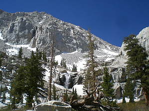
Highest Mount in Lower 48 States by Davis2001r6 Mt. Whitney at 14,497 feet is the highest mountain in the contiguous United States. It can be climbed year-round, but I'm just going to cover a summertime trip. Winter and Spring trips require technical gear and full winter mountaineering abilities. Permit A permit is required to climb the mountain, due to its popularity they limit the number of people allowed per day. As of 2008, they allow 60 overnight slots and 100-day hike slots. The Inyo National Forest is the authority on issuing permits. To apply for a permit in advance there is a lottery that is held in February, there is a per person reservation fee. If you didn't get lucky enough to land your preferred date in the lottery all permits that haven't been picked up do get released to walk-in customers. For 2007 there was only ONE day that had no permits un-claimed. Also, there is no reservation fee if you get a walk-up permit.
The trailhead is at Whitney Portal at an elevation of 8360'. Camping is allowed at Outpost Camp at 10,365' as well as Trail Camp at 12,000 feet. A bear canister approved by the Sierra Interagency Black Bear Group is required for overnight camping. Water Water is available at numerous places along the trail up until Trail Camp. There is no reason for carrying more than a few liters of water except for the summit attempt as there is no water available past trail camp. Water should be treated, filtered, or boiled before drinking. Waste The mountain has a pack it in pack it out policy. That includes solid human waste. "Wag" bags are available for free from the ranger station in Lone Pine where you have to pick up the permit. They will give you the same briefing. With the area seeing 100+ visitors a day that is A LOT of waste. The wag bags work and do not have any smell to them, think of them as multilayer trash and zip lock bag with a kitty litter formula inside as well. Please follow this policy as anywhere you would like to "dig" a hole, is most likely going to be near water or snow and eventually seep back into the same creeks and lakes we are getting out water from. Timing The summer season is known for its afternoon thunderstorms, that why a very early start is recommended. Lightning strikes are very common on the summit as well as the ridge leading to the summit, if any weather is approaching, turn around and descend, do not continue towards the summit. The trail is very easy to follow by headlamp or even a full moon if you time it right. Plan on it taking longer for each mile as you're hiking at high elevation and going to be struggling to breathe. Your body just won't let you go as fast at altitude. A good formula that I came across for figuring time is 1.5 miles per hour plus an additional 30 minutes for every 1,000 feet gained. I think that formula is pretty accurate for an average hiker. Warning Some people do get Acute Mountain Sickness (AMS) or known as Altitude Sickness as well at the higher elevations. Some people are not affected by the altitude at all, others may just develop a slight headache. Worse cases will cause people to vomit and can eventually lead to High Altitude Pulmonary Edema (HAPE) or High Altitude Cerebral Edema (HACE) both can be life-threatening but can be curred by simply descending in altitude. There are some good articles on preventing Altitude Sickness on the net, do a bit more research before you embark on your adventure. Trail Mileages and Elevations
Check out the Official Route and Triplogs. Note This is a difficult hike. It would be insane to attempt this entire hike without prior experience hiking. Leave No Trace and +Add a Triplog after your hike to support this local community. | |||||||||||||||||||||||||||||||||||||||||||||||||||||||||||||||||||||||||||||||||||||||||||||||||||||||||||||||||||||||||||||||||||||||||||||||||||||||||||||||||||||||||||||||||||||||||||||||||||||||||||||||||||||||||||||||||||||||||