username
X
password
register
for free!
help


Blue Ridge - Goldfield Mtns, AZ

Guide 31 Triplogs  0 Topics
  3.3 of 5  
Fav
Wish
1
details
drive
no permit
forecast
route  
stats
photos
triplogs
topics
location
537 31 0
Statistics
tap row or icons for details
Difficulty 2 of 5
Distance One Way 2.1 miles
Trailhead Elevation 2,053 feet
Elevation Gain 348 feet
Accumulated Gain 911 feet
Kokopelli Seeds 5.14
 Interest Perennial Creek
feature photo
Photos Viewed All MineFollowing
Will recalculate on button tap!
13  2024-01-08
Dome Mountain 3381 - Goldfield Mtns
LindaAnn
28  2023-03-17
Idaho Trailhead to Cyclops
Yoder
27  2023-03-05
Goldfields sampler
LindaAnn
28  2023-03-05
Dome Mountain 3381 - Goldfield Mtns
00blackout
18  2023-01-08
Bulldog Canyon - Blue Ridge Loop
tibber
25  2022-04-09
Dome Mtn - 3 Lesser Peaks - Elliptical Arch
John10s
15  2022-03-09
Idaho Trailhead to Cyclops
Yoder
10  2022-02-13
Bulldog Keyhole Arch Loop
markthurman53
Page 1,  2,  3,  4
Author
author avatar Guides 16,843
Routes 17,472
Photos 24
Trips 1 map ( 6 miles )
Age 28 Male Gender
Location HAZ, TrailDEX
Associated Areas
list map done
Phoenix Region
Historical Weather
Trailhead Forecast
Radar Map
Expand Map
Preferred Jan, Dec, Feb, Nov → 7 AM
Sun  6:03am - 6:46pm
Official Route & 3 Rts
 
14 Alternative


remove free decal offer
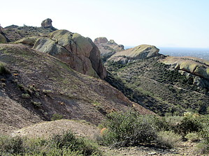
between green and violet
by HAZ_Hikebot

 
An interesting trail hike in an area previously abused by motor vehicles. The forest service is trying to curb the activity. This hike is open to mountain bikes hiking and horses and is an urban hike as the valley is generally visible. Overlooked by many, there are few others on the trail. The trail starts as a jeep road but quickly turns into singletrack. At the junction with Orohai Trail, a right turn will bring you to Keyhole Arch or the Packsaddle trailhead. A nice edge-of-town hike.


2018-07-14 HAZ_Hikebot


    Check out the Official Route and Triplogs.
    Leave No Trace and +Add a Triplog after your hike to support this local community.

    One-Way Notice
    This hike is listed as One-Way.

    When hiking several trails on a single "hike", log it with a generic name that describes the hike. Then link the trails traveled, check out the example.
    WARNING! Hiking and outdoor related sports can be dangerous. Be responsible and prepare for the trip. Study the area you are entering and plan accordingly. Dress for the current and unexpected weather changes. Take plenty of water. Never go alone. Make an itinerary with your plan(s), route(s), destination(s) and expected return time. Give your itinerary to trusted family and/or friends.

     Permit $$
    None


     Directions
    or
     Road
    FR / Dirt Road / Gravel - Car Okay

    To Bulldog Canyon Gate Trailhead
    From US60
    Highway 60 to Apache Junction exit Idaho north to McKellips, turn right on McKellips and go one-half mile to Wolverine and turn left to Tonto drive. Right on Tonto Drive(pavement ends) to Cactus, Left turn on Cactus (north), east on McDowell, and follow it to the trailhead where FS 10 is blocked by a locked iron gate.

    From Loop 202 & Brown: 8.9 mi / about 16 mins
    1. Head east on E Brown Rd toward N 86th St ○ 3.9 mi
    2. Turn left onto N Meridian Dr ○ 1.0 mi
    3. Turn right onto W McKellips Blvd ○ 2.5 mi
    4. Turn left onto N Wolverine Pass Rd ○ 0.9 mi
    5. Turn right onto E Tonto St ○ 0.2 mi
    6. Turn left onto N Cactus Rd ○ 0.1 mi
    7. N Cactus Rd turns right and becomes E McDowell Blvd ○ 387 ft
    8. E McDowell Blvd turns left and becomes N Cactus Rd ○ 0.1 mi
    5300-5498 N Cactus Rd, Apache Junction, AZ 85119

    If you plan ahead, you may drive the Bulldog Canyon OHV (off-highway vehicle), there's an admin fee, and you will need a 4x4 vehicle for many sections of the road.

    Information on the Bulldog canyon OHV permit

    From PHX (I-10 & AZ-51) - 41 min (38.9 miles)
    From TUC (Jct 1-10 & Grant) - 1 hr 52 min (103 miles)
    From FLG (Jct I-17 & I-40) - 2 hr 39 min (179 miles)
    page created by AZLOT69 on Mar 12 2012 5:52 pm
     90+° 8am - 6pm kills
    helpcorrectionissue

    end of page marker