Route Editor

| Guide | ♦ | 10 Triplogs | 0 Topics |
details | drive | permit | forecast | route |
stats |
photos | triplogs | topics | location |
| 23 | 10 | 0 |
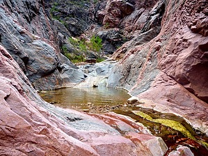
A real knockout! by chumley   Sockdolager Rapid is located at the beginning of the Grand Canyon's Granite Gorge at mile 78.5 of the Colorado River, where the perennial trickle of Hance Creek drains. It is worth noting that most Grand Canyon rapids are named after the creek drainages that created them. However, Hance Rapid is located at the bottom of Red Canyon, thereby leaving a vacancy for the rapid at the bottom of Hance Creek. Here you have, Sockdolager! Sockdolager Rapid is located at the beginning of the Grand Canyon's Granite Gorge at mile 78.5 of the Colorado River, where the perennial trickle of Hance Creek drains. It is worth noting that most Grand Canyon rapids are named after the creek drainages that created them. However, Hance Rapid is located at the bottom of Red Canyon, thereby leaving a vacancy for the rapid at the bottom of Hance Creek. Here you have, Sockdolager!Access to Sockdolager can be made on foot from the at-large camp located at the junction of the Tonto Trail and Hance Creek, just at the top of the Tapeats (Grand Canyon National Park camping permits required). It is an ideal day trip for anybody spending a couple of nights camping at Hance Creek or those who arrive early in the day from another camp such as Hance Rapid or Horseshoe Mesa.
WARNING This is an off-trail route and requires careful attention to route-finding, quite a bit of class-3 scrambling, and one short climb. This route should only be attempted by those with previous experience in off-trail hiking in the Grand Canyon or other hot desert locales. The mileage is deceptively short for the amount of energy that will be exerted. Plan accordingly. Route Description Begin at the Hance Creek campsite at the Tonto Trail's junction and head downstream along the trickle of Hance Creek. As the creek cuts through the Tapeats, a handful of shady Cottonwood trees grow in the canyon walls' shadows, offering beautiful contrasts of color. Bypass #1: After about 2 miles of relatively easy stream-bed hiking, you will reach the first dryfall. The bypass for fall #1 begins about 150 yards back upstream. There should be some cairns to mark the exit up the east canyon wall. The climb ascends about 250 feet steeply along a sharp crevice full of scree to a ridge before descending a much more gentle slope back down to the creek. Once the exit has been located, the route should be relatively easy to find for anybody with experience in desert route-finding. Bypass #2: The 2nd bypass begins only about 200 yards downstream from where the first bypass returns you to the creek. It heads up another very steep and rocky crevice, this time on the west side of the canyon, again gaining about 250 feet before beginning another much more moderately sloped descent that drops through loose and sandy terrain as well as a large rockslide that requires careful footing throughout. If you miss the exit for Bypass #2, it will take you 0.25 miles before you reach the fall, and you will have to backtrack to find the bypass exit. Chockstone Obstacles: About half a mile downstream of Bypass #2, you will reach a chockstone that leaves a good 10-foot overhung drop that upon first glance seems impassable. There is however, a nice crack in the granite on the east side that is loaded with excellent hand and footholds and makes for a quick down-climb. Not much farther, another chockstone creates another obstacle, but this one is easily traversed on the west side through some trees and brush with no climbing required at all. Bypass #3: The final obstacle occurs just before reaching the river. Another fall that is too high to negotiate without gear. This is the easiest of the three bypasses and begins about 150 yards upstream of the fall on the west side of the canyon. Again, you should find cairns marking the exit. This route climbs only about 150-feet higher, a significantly easier route than the previous two. At the crest of the route, you will see the rapids and feel the breeze that accompanies the roaring sound of the rushing Colorado River that you have been able to hear for the past few minutes. Descend to the river on the obvious route. The return trip follows the same route, and hopefully, you will have noted your bypass exit points for the return trip. I recommend taking the extra time to hike in the creek bed to each of the falls, especially #1 and #2, which are quite impressive and would be especially memorable during higher rates of creek flow. Camping There is no beach at Sockdolager Rapid. There is no established campsite and camping here is not recommended. Water Hance Creek has water in it for most of the hike, though during dryer months it may run underground in sections. Water from both Hance Creek and the Colorado River should be treated or filtered before drinking. Time For hikers who have not previously made this trip, I would plan on a minimum of 5-6 hours to complete this route, though people familiar with the exact route may find it possible to complete in under 4 hours. Hiking time is highly variable. This is just the author's guesstimate. Please know your tendencies and plan accordingly. Check out the Official Route and Triplogs. Note This is a moderately difficult hike. Leave No Trace and +Add a Triplog after your hike to support this local community. | |||||||||||||||||||||||||||||||||||||||||||||||||||||||||||||||||||||||||||||||||||||