Overview
This trail is named after an old structure that's relatively easy to find along its route. Whether you approach it from the west or the east, and even though it's a short jaunt of barely a mile, you will gain a new appreciation and love for the McDowell-Sonoran Preserve by the time you complete it.
Hike
The Windmill Trail runs for 1.1 miles. Most hikers will access it while heading east from the intersection of the Bell Pass / Windgate Pass trails. It can also be reached from the East End Trail if you are heading down and southbound from Tom's Thumb. Or it can be accessed while heading westbound from the Coachwhip Trail.
My access point was southbound from the East End Trail and Tom's Thumb, which placed me within eyeshot of the Bell Pass/Windgate Pass intersection, just a few yards away. At this point, you are surrounded by gorgeous and diverse scenery in each direction. To your back is Tom's Thumb and the East End peaks. Ahead and to your right are the trails leading straight into the McDowell Mountains, up to Windgate Pass, and beyond. To your left is your route along the Windmill, with the Superstition Mountains 40 miles away visible in the background. If you have the freedom to pick any one of those directions at random depending on which ones look more delicious to you at that moment, we should all be so lucky. But if you choose to hike along the Windmill, eastbound, you'll enjoy a relatively flat, slightly downhill stroll until connecting to the Coachwhip Trail.
I should point out that I lost the trail for a few brief moments and was only saved because I'd downloaded a GPS track. For about 10 minutes, I found myself doing some light bushwhacking through a dry creekbed that I'd mistaken for the trail before looking at my device and seeing that I was off-trail. Whether this was my carelessness or because the trail was easy to lose, you can judge yourself. But other than that minor slip-up, I had no route-finding difficulty. As for "the windmill" itself, you can spot it if you're paying attention without leaving the trail. It is standing south of the trail.
Water Sources
None. Bring ample water for hot, desert hiking during warm weather.
When hiking several trails on a single "hike", log it with a generic name that describes the hike. Then link the trails traveled, check out the example.
WARNING! Hiking and outdoor related sports can be dangerous. Be responsible and prepare for the trip. Study the area you are entering and plan accordingly. Dress for the current and unexpected weather changes. Take plenty of water. Never go alone. Make an itinerary with your plan(s), route(s), destination(s) and expected return time. Give your itinerary to trusted family and/or friends.
Permit $$
None
Directions
Road
Connector trail - Not Applicable
To Tom's Thumb Trailhead 1) 101 (Pima Freeway) to Frank Lloyd Wright
2) East on Frank Lloyd Right to N Thompson Peak Parkway
3) North on Thompson Peak Parkway to McDowell Sonoran Preserve Gateway Trailhead to drop off first vehicle
4) Then North on Thompson Peak Parkway to Pima Rd
5) North on Pima Rd to Happy Valley Rd
6) East on Happy Valley Rd until it turns north and changes to 116th st.
7) East on Ranch Gate Rd to 128th St
8) South on 128th to Park Entrance
From Exit 36 of AZ-101 Loop North, head northeast on North Pima Rd 4.7 miles to East Happy Valley Road. Turn right onto East Happy Valley Road and drive 4.3 miles to Ranch Gate Road. Turn right onto Ranch Gate Road and travel 1.3 miles and then turn right onto North 128th Street. After 1.0 mile on North 128th Street, you'll be at the trailhead gate. No water at the trailhead! Bathrooms are non-flush.
Warning
If you just pop in the coordinates of the trailhead, it's very possible that your GPS unit will tell you to wrong turn from Happy Valley Road onto Alameda Road at ( 33.706667, -111.832396 ). Don't do it! Those GPS units don't know that there's a locked gate at (33.694441, -111.813335).
From PHX (I-10 & AZ-51) 34.8 mi, 55 mins From TUC (Jct 1-10 & Grant) 135 mi, 2 hours 24 mins From FLG (Jct I-17 & I-40) 149 mi, 2 hours 37 mins
page created by trekkin_gecko on Aug 19 2014 4:57 pm
 Route Editor

 Overview
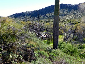


