Coachwhip Trail is a connector trail within the MMRP, named after the snake species that's often found in the area. I'll describe it from the east-bound vantage point, coming from the MSP/Scottsdale side. The official map identifies it as having two branches that meet at a V-point from the Windmill Trail. The Windmill is an MSP trail that crosses the MMRP boundary for a short distance. The boundary is officially marked by signs from both Maricopa County and the City of Scottsdale. Shortly after passing the border, you'll see another official sign for Coachwhip. You can then take either the southern or northern section of the horizontal "V." Taking the north portion, i.e., turning left, will connect you with the Pemberton Trail within MMRP after 1.8 miles. This is a pretty flat walk along the trail that is well-marked, smooth, and ideal for mountain bikers (whom you'll probably see more than hikers). I saw many wildflowers during my hike here in August. Your hike east-bound gives you direct views of the Superstition Mountains.
Taking the southern portion, i.e., turning right at the Windmill-Coachwhip intersection, will take you to the Dixie Mine Trail after 0.8 miles. The official distance of this trail, 2.6 miles, assumes that you would hike along both sections of the "V." Most hikers won't do that, so take note of which leg you wish to take.
As always, bring ample water if you are hiking in this area in warm weather, and educate yourself on desert hiking if you're unfamiliar with Arizona trails. The sun can be relentless. Some shade can be found underneath mesquite and palo verde trees.
When hiking several trails on a single "hike", log it with a generic name that describes the hike. Then link the trails traveled, check out the example.
WARNING! Hiking and outdoor related sports can be dangerous. Be responsible and prepare for the trip. Study the area you are entering and plan accordingly. Dress for the current and unexpected weather changes. Take plenty of water. Never go alone. Make an itinerary with your plan(s), route(s), destination(s) and expected return time. Give your itinerary to trusted family and/or friends.
McDowell Mountain Regional Park Regional Park 2023
Vehicle entry $7.00
Hike/Bike/Equestrian $2.00
Directions
Road
Connector trail - Not Applicable
To Tom's Thumb Trailhead 1) 101 (Pima Freeway) to Frank Lloyd Wright
2) East on Frank Lloyd Right to N Thompson Peak Parkway
3) North on Thompson Peak Parkway to McDowell Sonoran Preserve Gateway Trailhead to drop off first vehicle
4) Then North on Thompson Peak Parkway to Pima Rd
5) North on Pima Rd to Happy Valley Rd
6) East on Happy Valley Rd until it turns north and changes to 116th st.
7) East on Ranch Gate Rd to 128th St
8) South on 128th to Park Entrance
From Exit 36 of AZ-101 Loop North, head northeast on North Pima Rd 4.7 miles to East Happy Valley Road. Turn right onto East Happy Valley Road and drive 4.3 miles to Ranch Gate Road. Turn right onto Ranch Gate Road and travel 1.3 miles and then turn right onto North 128th Street. After 1.0 mile on North 128th Street, you'll be at the trailhead gate. No water at the trailhead! Bathrooms are non-flush.
Warning
If you just pop in the coordinates of the trailhead, it's very possible that your GPS unit will tell you to wrong turn from Happy Valley Road onto Alameda Road at ( 33.706667, -111.832396 ). Don't do it! Those GPS units don't know that there's a locked gate at (33.694441, -111.813335).
From PHX (I-10 & AZ-51) 34.8 mi, 55 mins From TUC (Jct 1-10 & Grant) 135 mi, 2 hours 24 mins From FLG (Jct I-17 & I-40) 149 mi, 2 hours 37 mins
 Route Editor

 Coachwhip Trail is a connector trail within the MMRP, named after the snake species that's often found in the area. I'll describe it from the east-bound vantage point, coming from the MSP/Scottsdale side. The official map identifies it as having two branches that meet at a V-point from the Windmill Trail. The Windmill is an MSP trail that crosses the MMRP boundary for a short distance. The boundary is officially marked by signs from both Maricopa County and the City of Scottsdale. Shortly after passing the border, you'll see another official sign for Coachwhip. You can then take either the southern or northern section of the horizontal "V." Taking the north portion, i.e., turning left, will connect you with the Pemberton Trail within MMRP after 1.8 miles. This is a pretty flat walk along the trail that is well-marked, smooth, and ideal for mountain bikers (whom you'll probably see more than hikers). I saw many wildflowers during my hike here in August. Your hike east-bound gives you direct views of the Superstition Mountains.
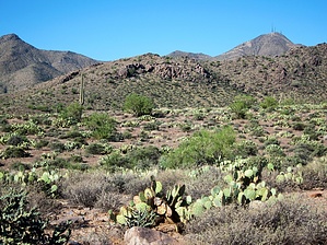


