Route Editor

| Guide | ♦ | 21 Triplogs | 2 Topics |
details | drive | permit | forecast | route |
stats |
photos | triplogs | topics | location |
| 241 | 21 | 2 |
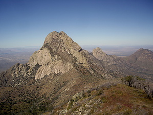
Inexorably Up!! by imike  That is what many of the local hikers call this "trail" route to the top of the mountain. If you look at the mileage and elevation gain it appears to come in just slightly worse than Finger Rock Trail over in Tucson. The numbers do not tell an accurate story. The first two miles approaching the mountain are mild, winding up and into the north side of Fillmore Canyon. The easy ends at that point. From Yellow Rocks on up it is a scramble, with very poor footing. At times it climbs at over 2,000' per mile. Normally, the route is overgrown and unclear, often forcing extra efforts through ever steeper scree. It demands some technical moves just below the top; not for everyone.
I suggest that you should review the available triplogs to get a better idea of what you might be getting into; they tell a more complete story than can be included in this description. Your day will start well... from the La Cueva Picnic area, follow the trails over to the Fillmore Canyon Trail. Following that official trail, just before you enter the canyon grotto at the old mine site, instead of going into the canyon, move to your left up and around the old mine. The trail should be clear, and will remain clear for the first two miles up to Yellow Rocks. About a mile into the hike you may notice a trail coming in from your left... that is the alternative route over from the old jeep road. (If you want an earlier start to your day than the 8am opening to Dripping Springs, consider hiking in from the jeep route). At Yellow Rocks, the very obvious large fin of yellow rock, the nature of the hike changes. Looking up towards the towering Needles, you will notice that the strata below is distinctively darker. This Gray Prominence will keep you company for the next section of your hike. You will hike up then adjacent to this darker rock. Ideally, the trail will be cleared out (as it currently is) and you will not have any problems following the best route. It tends to stick close to the right hand side of all that dark rock. Working your way up, around and through this challenging area (folks tend to fall more here in the loose footing)you will eventually reach Juniper Saddle. For a very brief reprieve you have a flat area, shade and great vistas. Leaving the saddle, you once again climb ever more steeply, winding your way up and into and through the Dark Canyon area. It is narrow and overgrown. If you are lucky the locals will have recently opened it up. Finally, you will reach the upper saddle, and have views off and over the east side of the mountain. Effectively, the hard work is done at this point. You will drop over and off the saddle, working your way sharply left. There is a cleared out route dropping steeply down next to the rock face on your right... it drops too far down... do not follow that decline, but stay high and to your left. You will soon encounter a rocky area that is the technical climb part of the route. Scramble up to the obvious lateral crack that will carry you on up and across to the upper part of the mountain. If you can make it past this last obstacle you are effectively on top of Organ Needle Peak. This highest point in the Organ Mountains is a challenge, but well worth the effort. Come prepared. Check out the Official Route and Triplogs. Note This is a difficult hike. Arrive fit and prepared or this could get ugly. Leave No Trace and +Add a Triplog after your hike to support this local community. | ||||||||||||||||||||||||||||||||||||||||||||||||||||||||||||||||||||||||||||||||||||||||