username
X
password
register
for free!
help
  
  🔥

Lone Mountain - Sycamore Creek, AZ

Guide 2 Triplogs  1 Topic
  3.5 of 5  
Fav
Wish
0
details
drive
no permit
forecast
🔥
route  
stats
photos
triplogs
topic
location
8 2 1
Statistics
tap row or icons for details
Difficulty 3 of 5
Route Finding 1 of 5
Distance Round Trip 0.62 miles
Trailhead Elevation 2,721 feet
Elevation Gain 486 feet
Accumulated Gain 486 feet
Avg Time Round Trip 0.75 hours
Kokopelli Seeds 3.05
 Interest Off-Trail Hiking & Peak
 Backpack Possible - Not Popular
unreported if dogs are allowed
editedit > ops > dogs to adjust
feature photo
Photos Viewed All MineFollowing
Inaugural Calculation on Button Tap!
10  2014-01-26
Sugar Loaf to Verde / Needle Rock
topohiker
8  2012-04-02 CannondaleKid
Author
author avatar Guides 44
Routes 162
Photos 24,766
Trips 2,411 map ( 18,558 miles )
Age 75 Male Gender
Location Mesa, AZ
Associated Areas
list map done
Phoenix Region
Historical Weather
Trailhead Forecast
Radar Map
Expand Map
Preferred Mar, Nov, Feb, Jan → 8 AM
Seasons   Late Autumn to Spring
Sun  6:02am - 6:48pm
Official Route
 
0 Alternative
 
Historic Fire Perimeteracres
🔥 2019 Verde Fire2.7k


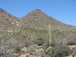
Short, steep and lonely
by CannondaleKid

  
Overview
Lone Mountain is in the general Sycamore Creek area just west of SR87 as you head north to Payson. While Lone Mountain is not all by its lonesome, it seems like a lonely looking peak as you drive by on FR1096. There isn't anything special about it, but it was 'one more peak to climb,' so that's all it took to be worthy for me. That said, once at the summit, the views are fantastic. You can see Granite Mountain to the north, Four Peaks to the east, Sheep Mesa, and the Sycamore Creek valley to the southeast and south.


Hike
From the 'trailhead' wherever you park along FR1096, it's just a matter of picking the best route between the various cacti and thorn bushes, climbing to the summit. BTW, you'll pick up tons of fox-tail in your shoes/socks along the way, so I'd recommend wearing bare feet in Teva sandals. For me, the STEEP climb was strenuous but easier on the knees than the STEEP return downhill.
remove free decal offer
The drive will take as much as four times as long as the climb to the summit, so once at the summit, you might want to cast an eye around for another goal to make the trip worthwhile. Sheep Mesa just to the east would be a great partner hike to this one.

2012-04-02 CannondaleKid


    Check out the Official Route and Triplogs.
    Leave No Trace and +Add a Triplog after your hike to support this local community.
    WARNING! Hiking and outdoor related sports can be dangerous. Be responsible and prepare for the trip. Study the area you are entering and plan accordingly. Dress for the current and unexpected weather changes. Take plenty of water. Never go alone. Make an itinerary with your plan(s), route(s), destination(s) and expected return time. Give your itinerary to trusted family and/or friends.

     Permit $$
    None


     Directions
    or
     Road
    Strictly 4x4

    To hike
    1. Take SR87 north to Sycamore Creek/Four Peaks turnoff and turn LEFT onto FR402.
    2. Continue on FR402 for 3.4 miles until you will need to cross the creek.
    3. On the other side of the creek you will be on FR1855, follow it for 2.0 miles to FR1856.
    4. Turn LEFT onto FR1856 and continue 1.7 miles to FR1096.
    5. Turn RIGHT onto FR1096 and continue about half a mile to the 'trailhead' which is anywhere you find an area wide enough to stop along the road without blocking it.

    NOTE: While you could reach the creek in step 2 by car, a high clearance 4x4 is recommended for steps 3-5.
    page created by CannondaleKid on Apr 02 2012 7:51 pm
     90+° 8am - 6pm kills
    helpcorrectionissue

    end of page marker