Route Editor

| Guide | ♦ | 3 Triplogs | 1 Topic |
details | drive | no permit | forecast | 🔥 route |
stats |
photos | triplogs | topic | location |
| 30 | 3 | 1 |
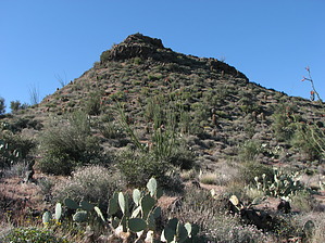
No sheep on this mesa by CannondaleKid  Overview OverviewThe drive from SR87 will take longer than the hike, so although the hike to the summit is less than 1/2 mile you'll probably want to make it worthwhile by worth following the mesa to the southern terminus then looping back along FR1096. Hike Starting from the trailhead your first decision will be whether you stay east or west of the fence-line that leads up to the false summit.
If you head directly toward the summit from the trailhead, you will be on the east side of the fence line. Personally, I'd recommend this way because there seem to be more open areas to help avoid the various thorny vegetation. Also, when the fence ends at the rock formation it's pretty easy to climb the rock up to the false summit and continue to the summit. The summit provides some great views, especially of the Sycamore Creek valley to the south. To make this a loop hike, continue toward the southwest and follow the mesa as it gradually drops down one level at a time, winding a bit more toward the west as you go. Continue until you come to a fence and again make your choice. Stay on the side you are already on and bushwhack along the fence until you reach FR1096, or since the fence has big gaps between the horizontal wires, just go through it and follow an unnamed hunting road until you reach FR1096. Turn right onto FR1096 and simply follow it through Black Mesa Tanks and back to the trailhead. Check out the Official Route and Triplogs. Leave No Trace and +Add a Triplog after your hike to support this local community. | |||||||||||||||||||||||||||||||||||||||||||||||||||||||||||||||||||||||||||||||||||||||||||||||||||||||||