Route Editor

| Guide | ♦ | 4 Triplogs | 1 Topic |
details | drive | no permit | forecast | route |
stats |
photos | triplogs | topic | location |
| 87 | 4 | 1 |
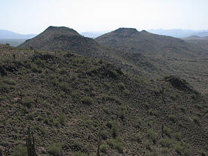
Up-down-up-down-up and back by CannondaleKid  Overview OverviewAdams Mesa is a series of ridges and mesas linked together in a generally east-west direction just south of the Sycamore Canyon wash. The peaks range from 2300 to 2500 feet in altitude. From the USGS marked summit, you will have a great view of the wide expanse of Sycamore Creek wash, Four Peaks, Fountain Hills, as well as the large houses spreading out over the hills immediately to the south. Beware, if you aren't a techno-geek or geo-head, be sure to skip this paragraph: The Adams Mesa quadrangle straddles the boundary between Proterozoic granitic and mid-Tertiary rocks of the Transition Zone and overlapping late Tertiary basin-fill sediments of the Lower Verde River Valley. The area is dominated by Sycamore Creek, which cuts diagonally across the quadrangle from northeast to southwest and defines the base level for most of the area.
Since the hike is entirely off-trail, there is an unlimited number of possibilities for a starting point and the route you choose. I drove 3/4 the way around a large loop before deciding to start with the western-most and lowest peak first, work east to the other end, and loop back to my start point. BTW, I wouldn't attempt to reach my start point with anything but an ATV or motorcycle. Or you could walk the extra 0.5 from Sycamore Creek wash. But in the end, I'd recommend a route closer to what is described below. Hike From your trailhead somewhere near N33.63291 W111.57935, climb in a northwesterly direction up the slope of the eastern-most peak. While the rocky parts may appear intimidating from below, they are that tough to traverse, and you'll come to like them more than the fox-tail-clad grassy areas you will encounter later. What worked well for me was to select the general direction for the next 1/8 to 1/4 mile, choose a landmark to head toward then alter the path around obstacles as they present themselves yet continuing on the general route. I'd also recommend following the mesas & ridges from one peak to the next rather than traversing the slopes. Once you've reached what you decide is your turn-around point, depending on your chosen start point and route, you may retrace your path or drop down and traverse the lower slope and make a loop hike out of it. Check out the Official Route and Triplogs. Leave No Trace and +Add a Triplog after your hike to support this local community. | |||||||||||||||||||||||||||||||||||||||||||||||||||||||||||||||||||||||||||||||||||||||||||||||