Route Editor

| Guide | ♦ | 19 Triplogs | 1 Topic |
details | drive | permit | forecast | route |
stats |
photos | triplogs | topic | location |
| 432 | 19 | 1 |
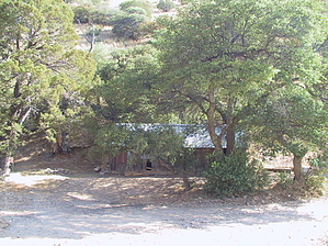
Where the streets have no name...literally. by Jeffshadows   Background BackgroundKeystone Peak is the highest point in the Sierrita Mountain range, roughly forty miles southwest of Tucson. The Sierrita is a freestanding range, rising from the valley floor to the summit at Keystone. The range is home to a great deal of mining activity, some of which dates back to the turn of the twentieth century. Since that time, the area has been home to the McGee family and now boasts a small township named "McGee Settlement," situated at the trail's entrance point. Starting down the trail, one encounters the "McGee Ranch Cemetery," which has been in use since the 1920s. After 2.6 miles, one encounters McGee Cabin, an abandoned mining cabin built-in 1911 by an ancestor of those still living in the area. The trail and Keystone Peak, all fall on private property, still owned by the McGee family, but they allow unfettered access to hikers, cyclists, and all-terrain vehicles. Sections of the trail are now leased to the Sierrita Mining & Ranching Company. Keystone Peak is adorned with multiple communications towers whose owners also lease the property from the McGees. Numerous live and abandoned mines dot the hillside as one ascends the trail. The "trail" itself is an improved dirt road requiring no technical ascent capability. The Hike After passing through and closing the gate near the water tank parking area, the trail wanders past the homes of the current McGee family embers residing in the area. Soon after that, the family cemetery is encountered just north of the trail. This section of the trail is level and well-shaded. Deer and squirrels seem to take refuge here and can be seen in abundance. Many side roads and trails break off from the main one. Some lead to mine workings and stock tanks, and others connect to other parts of the range. Most of these trails are unnamed, and some are unmapped. The main trail follows alongside a canyon bottom, slowly gaining grade until it suddenly begins to climb sharply toward Shiloh Pass, a saddle 1.3 miles from the trailhead. The views to the south from Shiloh Pass are fantastic, and Keystone Peak is not visible for the first time. After the pass, the trail breaks into three segments, continue along the trail to the right (northeast).
If there has been significant rain recently, one may wish to continue on the trail heading due west and down into Shiloh canyon. Numerous waterfalls exist along the granite outcroppings in the riparian canyon bottom. The trail winds its way northwest and then makes a hairpin turn and begins climbing with an increased grade along the ridge's south wall. A series of ever-increasingly large juniper populate this area, and you begin to notice a slight change in the surroundings, which have now become a scrub oak forest. Manzanita and juniper perfume the air, and the workings of a large mine tunnel and its tailings can be seen just across the canyon on the opposing wall below. For a while, the trail levels and begins a slow curve around the ridge heading back toward Placer Peak, which is directly south. After winding around the ridge and retaking a northwesterly course, the trail climbs a short grade, and in the trees just ahead, one can see McGee cabin roughly 2.7 miles in from the trailhead. The cabin is situated in a cleft between the ridge the trail was just following and another connecting from the northwest. A bench, a larger picnic table, and a permanent BBQ grill have been added to the site; however, many of the cabin's original accompaniments are still present. Just north of the cabin sits a well, and to the south and closer to the trail are the remains of an ore grinding pit. The trail climbs away from McGee cabin in a southerly direction heading toward Keystone Peak. Off-trail Option Just after leaving McGee Cabin, a rough and steep route drops into the canyon bottom opposite the cabin site and reconnects with the main trail after an eighth of a mile. Along this route lie a spring and some weathered water tanks. For the next mile and a half, the trail begins to wind into the hills facing away from Placer Peak and heading into a saddle just below Keystone Peak. The trail passes a large mine tunnel after turning northwest and climbing slightly. The grade along this stretch of trail is relatively consistent, and the trees become scarce, as does shelter from the sun. At just about three miles from the trailhead, Bills Spring is encountered. The spring appears to have water available year-round. Just after the spring, the trail begins to ascend steadily into a pass below Keystone Peak. Another trail disembarks here to the west, and the views west become expansive. On a clear day, you can see Kitt Peak and Boboquivari in detail. The trail turns south and begins to climb steadily just below and to the west of Keystone Peak. After circling behind Keystone, the trail crosses paths with a large, active mine tunnel. The trail continues to climb steadily until reaching a minor saddle overlooking Champurrado Wash to the south. Here the trail turns east and begins climbing sharply. The grade of the trail during this final quarter-mile climb onto the peak is similar to a staircase. Just below, a large mine and support structure are visible in Curparrado Wash. After matching elevation with the communications towers' bases, the trail makes a sharp left turn and joins the summit of Keystone Peak. You've come 4.2 miles, and the elevation is 6171 feet. The views are expansive. Grand vistas exist on the edges of the peak. The best way to take it all in is to walk the edge of the peak in a circle and explore. Author's Note When I was on the summit, I encountered a McGee family member who invited me to join him in climbing to a platform atop one of the communications towers. A series of "bolt pegs" forms a ladder, climbing some sixty feet to a small steel platform in the tower's center. He stated that the family didn't have a problem with visitors taking in this tower's view, provided they don't fall. However, be aware that some of the other towers and buildings belong to government agencies and should be left alone. Gate Policy: If a gate is closed upon arrival, leave it closed after you go through. If it is open, leave it open. Leaving a closed gate open may put cattle in danger. Closing an open gate may cut them off from water. Please be respectful, leave gates as found. The exception is signage on the gate directing you otherwise. Check out the Official Route and Triplogs. Leave No Trace and +Add a Triplog after your hike to support this local community. | ||||||||||||||||||||||||||||||||||||||||||||||||||||||||||||||||||||||||||||||||||||||||||||||||||||||||||||||||||||||||||||||||||||||||||||||||||||||||||||||||||||||||||||||||||