Overview
This is the final "up and over" leg to get up and back down from the summit of Sunrise Peak. This description is of the trail as hiked from east to west.
Warning
Areas of this trail are somewhat steep and slippery with loose dirt. Use caution and step carefully.
Hike
Even though this trail is less than one-half mile in length, it can be broken down into several different sections. After a 1.66-mile hike up from the Sunrise Trailhead [ photo ], you reach the saddle whereat can be found the eastern starting point of this spur trail, as indicated by a handy-dandy sign. Visible from this point is the tree that serves as the gateway to the summit area (as tagged on the photo in the photoset view, it is the first stand-alone tree [perched upon a small mound of rock] to the right of the large craggy outcropping above the sign). The trail leads up on the left of the sign through several short switchbacks for 0.08 miles to the most challenging stretch of the trail. Between the 0.08 and 0.13 marks, the trail first heads around to the right and then up a moderate grade to and between a couple of palo verde trees (visible in aerial photos situated on either side of the trail). The next 0.05 mile is a fairly level break that leads to the final spur to the summit, to your left, as indicated by a small sign (if you continue straight forward, you'll miss the summit and end up back on the Sunrise Trail). This final 0.06-mile push upward is at a relatively easy grade, but many of the rocks are fairly smooth.
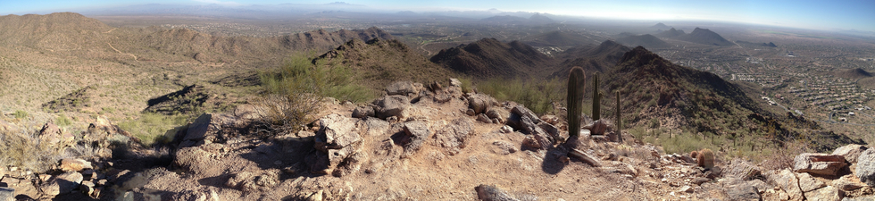
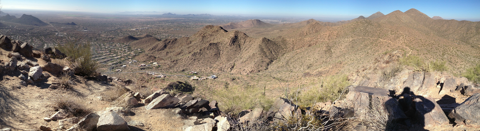
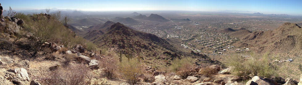
As you reach the tree you saw at the bottom of the spur (at the 0.24-mile mark), you have the choice of visiting the eastern summit to the left or the western summit to the right. At the eastern summit, you can look out to the southeast to Mesa and the east to Fountain Hills and the Four Peaks beyond. You can also get a look at the valley and trails/roads to the northeast. At the western summit, you can see Thompson Peak to the northwest, North Scottsdale to the west, and Camelback Mountain to the southwest. Finally, looking more south, you can see the Mayo Clinic and into the lands of the Salt River Pima Maricopa Indian Community.
When you've had your fill of these excellent vistas, and after walking the roughly 0.05 mile at the summit, you find yourself back at the gateway tree and the 0.29-mile mark. Taking care on the smooth rocks, you make your way back the 0.06 mile to the little sign pointing back up to the summit and turn left. After 0.04 miles, you reach the top of a set of easy switchbacks that take you the final 0.09 mile down to the Sunrise Trail (for a total length of 0.48 miles).
Water Sources
No water is available on this short spur trail.
Gate Policy: If a gate is closed upon arrival, leave it closed after you go through. If it is open, leave it open. Leaving a closed gate open may put cattle in danger. Closing an open gate may cut them off from water. Please be respectful, leave gates as found. The exception is signage on the gate directing you otherwise.
When hiking several trails on a single "hike", log it with a generic name that describes the hike. Then link the trails traveled, check out the example.
WARNING! Hiking and outdoor related sports can be dangerous. Be responsible and prepare for the trip. Study the area you are entering and plan accordingly. Dress for the current and unexpected weather changes. Take plenty of water. Never go alone. Make an itinerary with your plan(s), route(s), destination(s) and expected return time. Give your itinerary to trusted family and/or friends.
Permit $$
None
Directions
Road
Connector trail - Not Applicable
To hike From the Shea Boulevard offramp from Arizona Loop 101, head east 6.0 miles to 136th Street. Turn left onto North 136th Street and drive 0.5 miles north to Via Linda. Turn right, heading east, and then follow the road as it curves north 1.4 miles to the Sunrise Trailhead to the left of the community gate.
page created by joebartels on Dec 11 2012 12:56 am
 Route Editor

 Overview
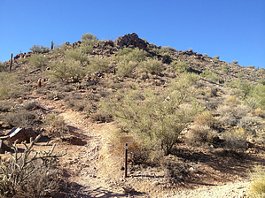


