Route Editor

| Guide | ♦ | 13 Triplogs | 0 Topics |
details | drive | no permit | forecast | map |
stats |
photos | triplogs | topics | location |
| 364 | 13 | 0 |
Grinders on the side by Hansenaz   Perry Mesa is located in Agua Fria National Monument and is chock full of history. The main access to the area is via the Bloody Basin Rd. off I-17 and from there a series of dirt roads provide access for ranchers and the public. Perry Mesa is located in Agua Fria National Monument and is chock full of history. The main access to the area is via the Bloody Basin Rd. off I-17 and from there a series of dirt roads provide access for ranchers and the public.Several hike descriptions have been posted giving details on how to find interesting ancient Pueblan sites in this area. Most are in poor condition, but often they have excellent petroglyph displays: these include Pueblo La Plata Ruins, Perry Tank Canyon Ruins, and Squaw Creek Ruins.
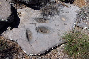
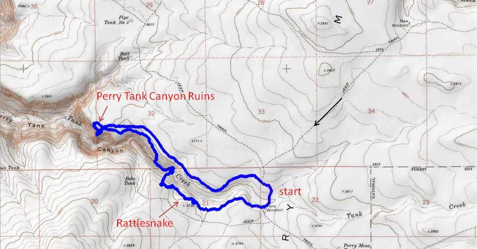
From Pueblo Pato, it's hard to see how this would work because the gorge is steep and looks pretty deep but the map shows that just a mile or two further upstream the canyon disappears and it's easy to get to the other side. The Perry Windmill is located at the head of the canyon. Accessible by one of those primitive dirt roads and a high clearance vehicle, it serves as the starting point for this loop hike. There is no trail for this loop and the traveling is mainly through knee-high grass with cactuses and rocks. Pretty much everything will stick you and the chiggers will bite so plan accordingly. From the Perry windmill (note this is not the first windmill you pass on the drive-in...it's a couple of miles further) contour along the southwest side of the deepening canyon. I thought the ruins would be along the edge with petroglyphs below. I soon came across a nice panel of glyphs and signs of a previous study (blue tape and white flags). Interestingly I didn't see anything nearby I could recognize as walls or ruins. What did stand out was the high number of metate-like grooves in the larger rocks. I saw more than 20 altogether. There was a lot of grinding going on along the side of this canyon 700 years ago. This first area had very little pottery debris but further along, there was more pottery and more of these "metates"...but again no ruins. There are so many signs of habitation in this area that different things will be noticed on every visit. After a while, it's time to head down into the canyon. I don't know where I would have normally chosen to descend but on this day there was a clear track trampled in the grass and I followed it. This led to a great area in the bottom with a large ruin, petroglyphs, and green pools of water. The water would have been the main attraction here for the former residents. From here it may be best to pick your way up the other side of the canyon but I continued down the canyon another half-mile or so, finding a few tiny pools but not much else. Once on the northeast side of the canyon head toward the high voltage towers to the northwest, the ones perched on the edge. Signs of habitation may be found....one thing I was curious about was a large number of big flattish volcanic rocks with smaller rocks piled on them. At the towers continue another quarter mile west to the Perry Tank Canyon Ruins. There is a small sign and a large area of overgrown ruin walls. Pottery sherds and flaked quartz and obsidian are everywhere. The excellent petroglyphs (much more vivid than at Rattlesnake) are mainly below the rim. When you've had your fill strike-off back toward your vehicle to complete the loop. You can stay close to the north side of the canyon (and probably stumble on more interesting stuff) or head due east to intersect a dirt road which will take you back with easier walking.
Check out the Triplogs. Leave No Trace and +Add a Triplog after your hike to support this local community. | |||||||||||||||||||||||||||||||||||||||||||||||||||||||||||||||||||||||||||||||||||