username
X
password
register
for free!
help


Drinkwater Peak - MSP, AZ

Guide 20 Triplogs  0 Topics
  3.4 of 5  
Fav
Wish
2
details
drive
no permit
forecast
map
stats
photos
triplogs
topics
location
247 20 0
Statistics
tap row or icons for details
Difficulty 2 of 5
Route Finding 2 of 5
Distance Round Trip 1.87 miles
Trailhead Elevation 3,999 feet
Elevation Gain 818 feet
Accumulated Gain 1,099 feet
Avg Time Round Trip 1 hour
Kokopelli Seeds 7.37
 Interest Off-Trail Hiking & Peak
feature photo
Photos Viewed All MineFollowing
2  2023-12-20
McDowell Mountain Mother Lode
pseudalpine
41  2023-11-06
McDowell Mountain Mother Lode
thesnakefromthel
14  2019-12-14 Nate_F
14  2019-04-24 Pickles
12  2016-01-01
McDowell Peak
GeeEss
7  2015-10-10
McDowell & Drinkwater Peaks
The_Dude
4  2014-11-30
McDowell and Drinkwater Peaks
trekkin_gecko
8  2014-01-04 johnlp
Page 1,  2
Author
author avatar Guides 59
Routes 1,100
Photos 1,191
Trips 1,290 map ( 9,859 miles )
Age Male Gender
Location Arizona
Associated Areas
list map done
Phoenix Region
Historical Weather
Trailhead Forecast
Expand Map
Preferred Nov, Dec, Jan, Feb → 6 AM
Seasons   Autumn to Spring
Sun  6:04am - 6:48pm
4 Routes
 
7 Alternative


remove free decal offer
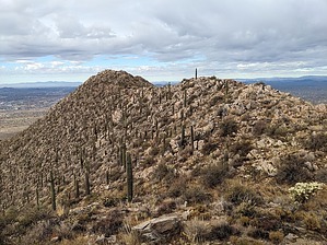
The "Herb" Made Them Do It
by pseudalpine

 
Overview
Named May 9, 2008, in honor of Herbert Drinkwater, Scottsdale City Councilman 1970 to 1978 and Mayor of Scottsdale from 1980 to 1996. In addition to the statue located at the Scottsdale Civic Center, this peak is a fitting tribute to his dedication at establishing the McDowell Sonoran Preserve and many of his other accomplishments as a popular public figure.


Hike Off-trail activities within the McDowell Sonoran Preserve are not permitted without written approval from the preserve manager. Otherwise, visitors are required to stay on mapped trails, or risk being ticketed by the occasional mountain bike police patrol. Under Sec.21-12 - General rules for use, (b)(6) is classified as a Class 2 misdemeanor which carries a $750 fine and is punishable by up to four months in jail.

2024-05-13 pseudalpine
  • 2018 Southern Region
    area related
    2018 Southern Region
  • 2018 Gateway
    area related
    2018 Gateway
  • 2018 Tom's Thumb
    area related
    2018 Tom's Thumb


Check out the Triplogs.
Leave No Trace and +Add a Triplog after your hike to support this local community.
WARNING! Hiking and outdoor related sports can be dangerous. Be responsible and prepare for the trip. Study the area you are entering and plan accordingly. Dress for the current and unexpected weather changes. Take plenty of water. Never go alone. Make an itinerary with your plan(s), route(s), destination(s) and expected return time. Give your itinerary to trusted family and/or friends.

 Permit $$
None

McDowell Mountain Regional Park Regional Park
2023
Vehicle entry $7.00
Hike/Bike/Equestrian $2.00


 Directions
or
 Road
Connector trail - Not Applicable

To hike
Connector trail - Not Applicable, but one would likely go over McDowell Peak twice to visit this summit.
page created by trekkin_gecko on May 13 2024 4:55 pm
 90+° 8am - 6pm kills
helpcorrectionissue

end of page marker