username
X
password
register
for free!
help
  This is likely a great time to hike this trail!  Check out "Preferred" months below, keep in mind this is an estimate.
  🔥

Promontory Trail #278, AZ

Guide 75 Triplogs  2 Topics
  3.4 of 5  
Fav
Wish
0
details
drive
no permit
forecast
🔥
route  
stats
photos
triplogs
topics
location
552 75 2
Statistics
tap row or icons for details
Difficulty 4 of 5
Route Finding 3 of 5
Distance One Way 0.7 miles
Trailhead Elevation 6,699 feet
Elevation Gain 1,010 feet
Accumulated Gain 1,010 feet
Kokopelli Seeds 4.07
feature photo
Photos Viewed All MineFollowing
Will recalculate on button tap!
1  2025-07-13
Derrick - Horton Loop
pseudalpine
3  2023-08-12
Promontory plus
pseudalpine
19  2023-05-06
Derrick - Horton Loop
astrobrewer
7  2023-04-19
Horton Super Loop Plus
pseudalpine
10  2022-11-12
Derrick - Highline - Promontory
PaysonRealtorAZ
9  2022-03-25 Yoder
4  2021-08-21
Promontory Butte 7914
hikerdw
21  2021-05-08
Derrick - Horton Loop
John10s
Page 1,  2,  3,  4,  5 ... 7
Author
author avatar Guides 16,843
Routes 17,472
Photos 24
Trips 1 map ( 6 miles )
Age 28 Male Gender
Location HAZ, TrailDEX
Associated Areas
list map done
Payson Region
Historical Weather
Trailhead Forecast
Radar Map
Expand Map
Preferred May, Oct, Sep, Apr
Sun  6:00am - 6:45pm
Official Route & 1 Rt
 
37 Alternative
 
Historic Fire Perimeteracres
🔥 1998 Promontory Fire4.9 mi**


remove free decal offer

  Likely In-Season!
Guide Needed
Publish Full Detail Guide


Use +Add above to share photos and triplogs


Happy

Trails!


  • guide related image guide related image guide related image
    guide related


Check out the Official Route and Triplogs.

Note
This is a moderately difficult hike.
Leave No Trace and +Add a Triplog after your hike to support this local community.

One-Way Notice
This hike is listed as One-Way.

When hiking several trails on a single "hike", log it with a generic name that describes the hike. Then link the trails traveled, check out the example.
WARNING! Hiking and outdoor related sports can be dangerous. Be responsible and prepare for the trip. Study the area you are entering and plan accordingly. Dress for the current and unexpected weather changes. Take plenty of water. Never go alone. Make an itinerary with your plan(s), route(s), destination(s) and expected return time. Give your itinerary to trusted family and/or friends.

 Permit $$
no fees or permits reported

if incorrect tell us about it


 Directions
or
 Road


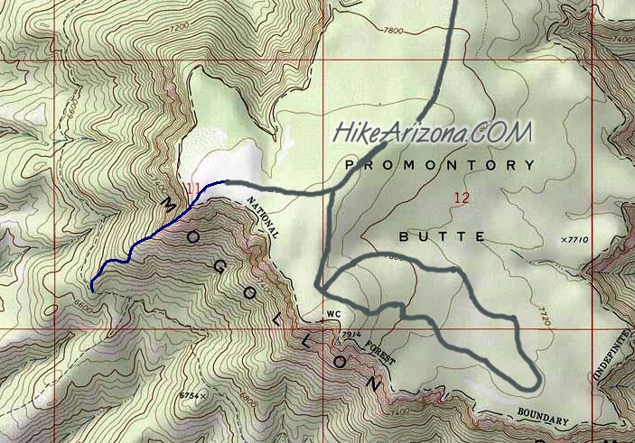
To hike
From Payson take 260 East for 31 miles to FR300, mile marker 282.4
Turn left up FR300 12.7 miles fo FR76
Follow FR76 2 miles to FR76B and follow B 1 mile to the end, staying left of the fork.
page created by joebartels on Jun 02 2012 10:29 pm
 90+° 8am - 6pm kills
helpcorrectionissue

end of page marker