Overview
Upper Bear Canyon is defined here as the "off-trail" hiking section from where the split of Upper Bear Canyon with East Bear Canyon intersect. As now written, this hike is an "out and back" beginning at the forced end of FR300G (due to Forest Service placed down trees). From the Parking/TH Start, this hike is a ~3.0 mile total one way to the uppermost end of Bear Canyon. It is also possible this hike could be a loop or shuttle hike if an additional, adequate upper Bear Canyon hike exit route and TH Parking location is later determined. Upper Bear Canyon "off-trail" hiking can be compared to hiking sections of our Mogollon Rim- Barbershop Canyon and Dane Canyon with significant seasonal water flow pooling as of this June'12 posting.
Note
For the stronger hiker with off-trail route-finding ability, you can combine with the Bear Canyon(Middle) hike for a longer 10+ mile shuttle hike.
When hiking several trails on a single "hike", log it with a generic name that describes the hike. Then link the trails traveled, check out the example.
WARNING! Hiking and outdoor related sports can be dangerous. Be responsible and prepare for the trip. Study the area you are entering and plan accordingly. Dress for the current and unexpected weather changes. Take plenty of water. Never go alone. Make an itinerary with your plan(s), route(s), destination(s) and expected return time. Give your itinerary to trusted family and/or friends.
Permit $$
None
Directions
Road
High Clearance possible when dry
To hike From Phoenix
Drive Hwy 87 north through Payson, Pine, and Strawberry.. approx 10.5 miles north of Strawberry on Hwy 87 at MP281.1, turn right at signed FR300 (the Rim Road), and continue on FR300 for ~14.5 miles to the intersection with signed FR300G. Turn left onto FR300G and continue for ~2.4 miles to its FR300G end at the Parking/TH Start for this off-trail hike (at waypoint 34.45698 -111.21131).
It is highly recommended that you download and follow the Driving Route (with key waypoints) posted to this guide.
page created by Grasshopper on Jun 13 2012 8:17 pm
 Route Editor

 Overview
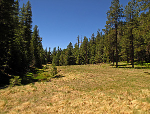


